File:Bakersfield Municipal Airport diagram.png

Size of this preview: 315 × 599 pixels. Other resolutions: 126 × 240 pixels | 444 × 844 pixels.
Original file (444 × 844 pixels, file size: 42 KB, MIME type: image/png)
Captions
Captions
Add a one-line explanation of what this file represents
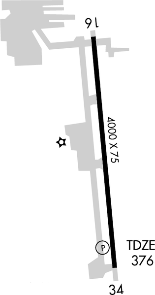
| Description | Airport diagram of Bakersfield Municipal Airport in Bakersfield, California |
| Date | |
| Source | http://www.naco.faa.gov/ |
| Author | Federal Aviation Administration |
| Permission (Reusing this file) |
Work of the FAA - Public Domain |
This image or file is a work of a Federal Aviation Administration employee, taken or made as part of that person's official duties. As a work of the U.S. federal government, the image is in the public domain in the United States.
|
 |
File history
Click on a date/time to view the file as it appeared at that time.
| Date/Time | Thumbnail | Dimensions | User | Comment | |
|---|---|---|---|---|---|
| current | 19:14, 14 December 2006 | | 444 × 844 (42 KB) | Epolk (talk | contribs) | {{Information |Description=Airport diagram of Bakersfield Municipal Airport in Bakersfield, California |Source=http://www.naco.faa.gov/ |Date=December 13, 2006 |Author=Federal Aviation Administration |Permission=Work of the FAA - Public Domain |other_vers |
| 19:09, 14 December 2006 |  | 768 × 1,118 (263 KB) | Epolk (talk | contribs) | {{Information |Description=Airport diagram of Bakersfield Municipal Airport in Bakersfield, California |Source=http://www.naco.faa.gov/ |Date=December 13, 2006 |Author=Federal Aviation Administration |Permission=Work of the FAA - Public Domain |other_vers |
You cannot overwrite this file.
File usage on Commons
The following page uses this file:
File usage on other wikis
The following other wikis use this file:
- Usage on en.wikipedia.org
- Usage on fa.wikipedia.org
- Usage on ru.wikipedia.org
- Usage on tg.wikipedia.org
- Usage on www.wikidata.org