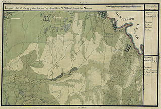
File:Banat Josephinische Landaufnahme pg024.jpg

Size of this preview: 800 × 544 pixels. Other resolutions: 320 × 217 pixels | 640 × 435 pixels | 1,024 × 696 pixels | 1,280 × 870 pixels | 2,560 × 1,739 pixels | 8,330 × 5,660 pixels.
Original file (8,330 × 5,660 pixels, file size: 26.65 MB, MIME type: image/jpeg)
Captions
Captions
Add a one-line explanation of what this file represents
| Name shown on the map Nume din hartă |
Administrative unit Unitate administrativă |
Romanian name Numele românesc |
Hungarian name Numele unguresc |
German name Numele german |
Serbian name Numele sârbesc |
Country today Ţara de astăzi |
|---|---|---|---|---|---|---|
| Neu Arad | Temes megye Komitat Temes Comitatul Timiş |
Aradu Nou | Újarad (Arad része) | Neu-Arad | Románia | |
| Engelsbrunn | Temes megye | Fântânele | Angyalkút, Kisfalud | Engelsbrunn | Románia | |
| Sanct Miklos | Temes megye | Sânnicolau Mic | Kisszentmiklós (Arad része) | Klein-Sanktniklas, Klein Sankt Nikolaus | Románia | |
| Segenthau | Temes megye | Şagu | Németság, Mezőság, Ság | Dreispitz, Saagh, Segenthau | Romania |
Summary edit
| Description |
Deutsch: Das Banat in: Josephinische Landesaufnahme, 1769-72. Josephinische Landaufnahme pg024 English: The Banat region in the cadastral maps: Josephinische Landesaufnahme, 1769-72. Josephinische Landaufnahme pg024 |
||||
| Date | between 1769 and 1772 | ||||
| Source | Österreichisches Staatsarchiv, Kriegsarchiv | ||||
| Author | Historische Militärkarte der österreichisch-ungarischen Monarchie | ||||
| Permission (Reusing this file) |
|
||||
Clickable map of the Banat region edit

File history
Click on a date/time to view the file as it appeared at that time.
| Date/Time | Thumbnail | Dimensions | User | Comment | |
|---|---|---|---|---|---|
| current | 07:55, 2 January 2010 | | 8,330 × 5,660 (26.65 MB) | Asybaris01 (talk | contribs) | new rez |
| 07:49, 2 December 2009 |  | 5,331 × 3,622 (17.3 MB) | Asybaris01 (talk | contribs) | {{Information |Description={{ro|1=Banat Josephinische Landaufnahme pg024}} |Source=Banat Josephinische Landaufnahme pg024 |Author=Asybaris01 |Date=12/02/2009 |Permission= |other_versions= }} Category:Josephinische Landaufnahme |
You cannot overwrite this file.
File usage on Commons
The following page uses this file:
File usage on other wikis
The following other wikis use this file:
- Usage on arz.wikipedia.org
- Usage on de.wikipedia.org
- Usage on hu.wikipedia.org
- Usage on ro.wikipedia.org
- Usage on tt.wikipedia.org
- Usage on www.wikidata.org