File:Bank on Waterpit Down - geograph.org.uk - 730643.jpg
No higher resolution available.
Bank_on_Waterpit_Down_-_geograph.org.uk_-_730643.jpg (640 × 480 pixels, file size: 94 KB, MIME type: image/jpeg)
Captions
Captions
Add a one-line explanation of what this file represents
Summary edit
| Description |
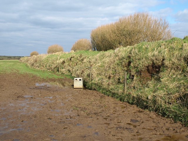
English: Bank on Waterpit Down North Cornwall has some no nonsense field boundaries. This enormous bank topped with bushes follows a line that can be traced as a linear cross-country feature for, at the least, several miles. That appears to be a discarded piece of kitchen equipment, but is presumably a cattle feeder. Seen from the no through lane to Trekeek. |
| Date | |
| Source | From geograph.org.uk |
| Author | Derek Harper |
| Attribution (required by the license) | Derek Harper / Bank on Waterpit Down / |
| Camera location | | View this and other nearby images on: OpenStreetMap |
|---|
_heading:45.00&language=en)
| Object location | | View this and other nearby images on: OpenStreetMap |
|---|
_heading:45.00&language=en)
Licensing edit

|
This image was taken from the Geograph project collection. See this photograph's page on the Geograph website for the photographer's contact details. The copyright on this image is owned by Derek Harper and is licensed for reuse under the Creative Commons Attribution-ShareAlike 2.0 license.
|
This file is licensed under the Creative Commons Attribution-Share Alike 2.0 Generic license.
Attribution: Derek Harper
- You are free:
- to share – to copy, distribute and transmit the work
- to remix – to adapt the work
- Under the following conditions:
- attribution – You must give appropriate credit, provide a link to the license, and indicate if changes were made. You may do so in any reasonable manner, but not in any way that suggests the licensor endorses you or your use.
- share alike – If you remix, transform, or build upon the material, you must distribute your contributions under the same or compatible license as the original.
File history
Click on a date/time to view the file as it appeared at that time.
| Date/Time | Thumbnail | Dimensions | User | Comment | |
|---|---|---|---|---|---|
| current | 07:20, 19 February 2011 | | 640 × 480 (94 KB) | GeographBot (talk | contribs) | == {{int:filedesc}} == {{Information |description={{en|1=Bank on Waterpit Down North Cornwall has some no nonsense field boundaries. This enormous bank topped with bushes follows a line that can be traced as a linear cross-country feature for, at the leas |
You cannot overwrite this file.
File usage on Commons
There are no pages that use this file.