File:Barentsz Full Map.jpg

Size of this preview: 800 × 594 pixels. Other resolutions: 320 × 237 pixels | 640 × 475 pixels | 1,000 × 742 pixels.
Original file (1,000 × 742 pixels, file size: 258 KB, MIME type: image/jpeg)
Captions
Captions
Add a one-line explanation of what this file represents
Summary
edit| Description |
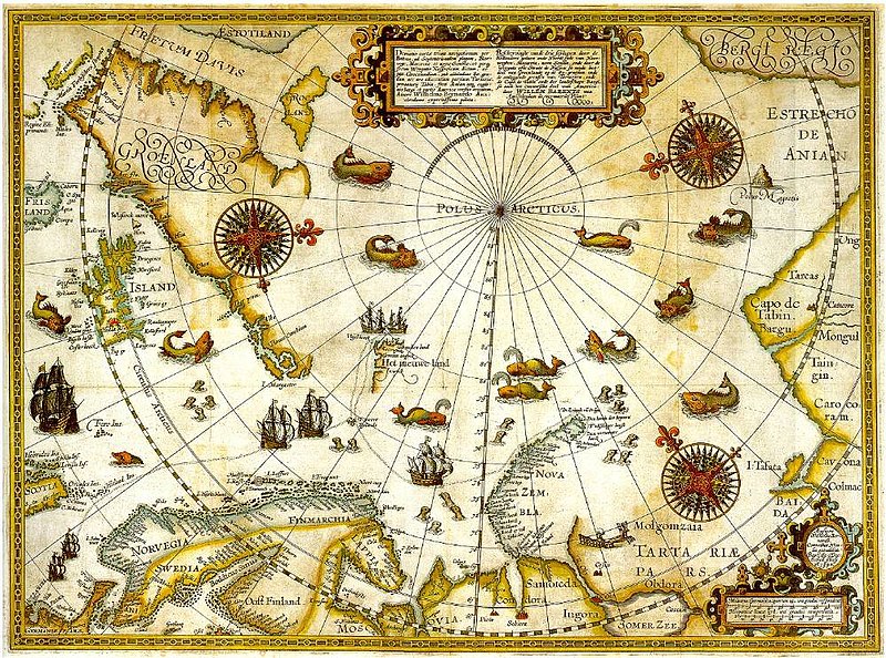
1598 map of the hree Arctic voyages (1594–1596) by Willem Barentsz. Delineatio cartae trium navigantium per Bataves, ad Septentrionalem plagam, Norvegiae, Moscoviae et novae Semblae Autore Wilhelmo Bernardo [1] [2] |
| Date | |
| Source | immediate source unknown, uploaded 2007 |
| Author | Willem Barentsz (Wilhelmus Bernardus) |
| Permission (Reusing this file) |
Public domain (over 70 years since creator's death) |
| Other versions |
|

.jpg)
_door_Willem_Barendsz_(titel_op_object),_NG-800.jpg)


Licensing
edit
|
This work is in the public domain in its country of origin and other countries and areas where the copyright term is the author's life plus 100 years or fewer. | |
| This file has been identified as being free of known restrictions under copyright law, including all related and neighboring rights. | |
File history
Click on a date/time to view the file as it appeared at that time.
| Date/Time | Thumbnail | Dimensions | User | Comment | |
|---|---|---|---|---|---|
| current | 22:20, 5 December 2007 | | 1,000 × 742 (258 KB) | Sherurcij (talk | contribs) | {{Information |Description=Portion of 1599 map of Arctic exploration by Willem Barentsz. Spitsbergen, here mapped for the first time, is indicated as "Het Nieuwe Land" (Dutch for "the New Land"), center-left. |Source=[http://www.ub.uit.no/northernlights/e |
You cannot overwrite this file.
File usage on Commons
The following 8 pages use this file:
- File:1598 map of the Polar Regions by Willem Barentsz.jpg
- File:Barents third voyage.jpg
- File:Barentskartet, 1598 (12068020364).jpg
- File:Barentsz arctic map.jpg
- File:Forminsket utgave av Barentskartet - no-nb krt 00487.jpg
- File:Kaart van de landen rond de poolcirkel met de drie reizen van de Nederlanders, 1598 Beschrijvinghe van de drie seylagien door de Hollanders gedaen ande Noordt syde van Noorweghen, Moscovia, nova Sembla, ende door het de, RP-P-OB-80.320.jpg
- File:Kaart van het Noordpoolgebied, 1598 Beschrijvinghe van de drie seylagien door de Hollanders gedaan (..) door Willem Barendsz (titel op object), NG-800.jpg
- File:Pontanus 1611 Arctic Map.jpg
File usage on other wikis
The following other wikis use this file:
- Usage on ar.wikipedia.org
- Usage on fr.wikipedia.org
- Usage on gcr.wikipedia.org
- Usage on kk.wikipedia.org
- Usage on nrm.wikipedia.org
- Usage on ru.wikipedia.org