File:Barrikadnaya (19776794810).jpg

Original file (5,520 × 3,680 pixels, file size: 4.79 MB, MIME type: image/jpeg)
Captions
Captions
Summary edit
.jpg&action=edit§ion=1)
| Description |
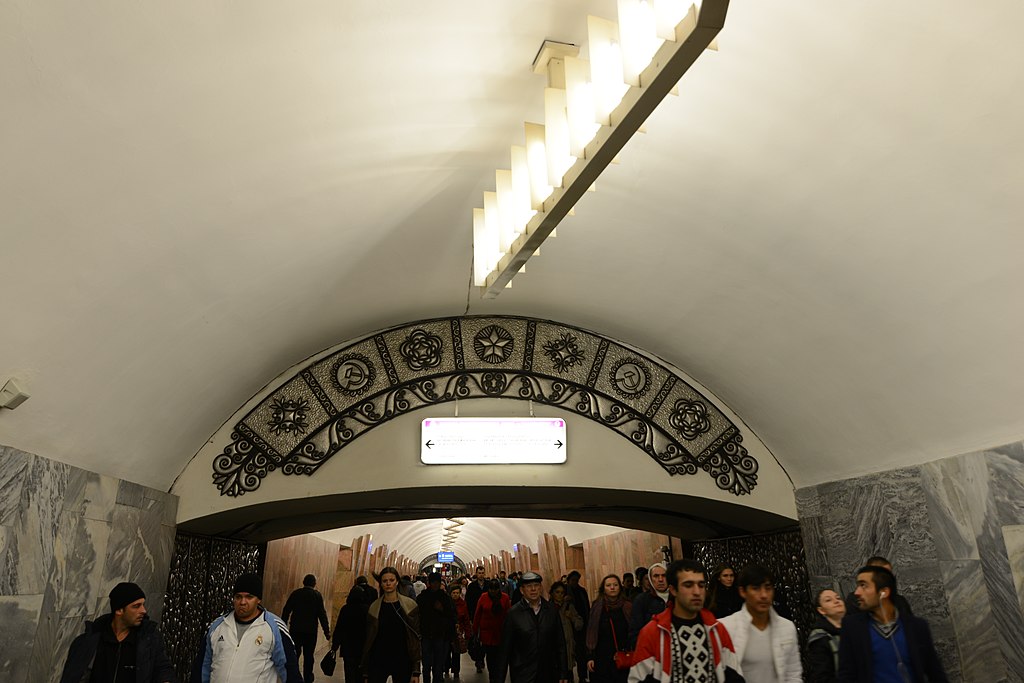
English: Barrikadnaya (Russian: Баррикадная) is a station on the Tagansko-Krasnopresnenskaya Line of the Moscow Metro. It is named after the events of the Revolution of 1905 when it was a site for barricades on Krasnaya Presnya street. The station was opened in 1972 as the first station on the Krasnopresenenskiy line, and for three years was its southern terminus, until the tunnel to Pushkinskaya connected it to the Zhdanovskiy line.
The station was built following a typical pylon design, however due to unfavourable underlying geological conditions the pylons eventually had to be widened. Decoratively the station shows that by the early 1970s the architectural style of Moscow Metro stations had evolved from the functional designs of the 1960s. The station architects Strelkov and Polikarpova applied a theme of pink and red marble to the pylons, which due to their extension from the floor to the vault appear to look like barricades. The walls are exquisitely decorated with different shades of pink, red, blue and grey marble. The central hall had to be extended as the station was initially designed for extended seven-carriage trains (although the line has been using eight-carriages since the late 1980s). This design is most obviously seen in the entrances to the central hall, which are all decorated with metallic artworks. The entrance to the station is located on Barrikadnaya Street, which links Krasnaya Presnya with the Garden Ring, and is externally decorated with stone artwork depicting the events of 1905. Across the road is one of Stalin's Seven Sisters skyscrapers. From the opposite end of the central hall there is a transfer to the Krasnopresnenskaya station of the Koltsevaya Line The daily passenger traffic of the station amounts to 32,400 people via the station entrance, and 118,500 using the transfer [Wikipedia.org] |
| Date | Taken on 6 October 2014, 18:26 |
| Source | Barrikadnaya |
| Author | Jorge Láscar from Melbourne, Australia |
| Camera location | | View this and other nearby images on: OpenStreetMap |
|---|
.jpg¶ms=055.775602_N_0037.655672_E_globe:Earth_type:camera_source:Flickr_&language=en)
Licensing edit
.jpg&action=edit§ion=2)
- You are free:
- to share – to copy, distribute and transmit the work
- to remix – to adapt the work
- Under the following conditions:
- attribution – You must give appropriate credit, provide a link to the license, and indicate if changes were made. You may do so in any reasonable manner, but not in any way that suggests the licensor endorses you or your use.
| This image was originally posted to Flickr by Jorge Lascar at https://flickr.com/photos/8721758@N06/19776794810 (archive). It was reviewed on 2 February 2018 by FlickreviewR 2 and was confirmed to be licensed under the terms of the cc-by-2.0. |
File history
Click on a date/time to view the file as it appeared at that time.
| Date/Time | Thumbnail | Dimensions | User | Comment | |
|---|---|---|---|---|---|
| current | 08:40, 2 February 2018 | | 5,520 × 3,680 (4.79 MB) | Thesupermat2 (talk | contribs) | Transferred from Flickr via Flickr2Commons |
You cannot overwrite this file.
File usage on Commons
The following page uses this file:
.jpg&oldid=867291833)