File:Bassas da India atoll map-fr.png
Size of this preview: 650 × 600 pixels. Other resolutions: 260 × 240 pixels | 520 × 480 pixels | 832 × 768 pixels | 1,110 × 1,024 pixels | 1,555 × 1,435 pixels.
Original file (1,555 × 1,435 pixels, file size: 371 KB, MIME type: image/png)
Captions
Captions
Add a one-line explanation of what this file represents
Summary edit
| Camera location | | View this and other nearby images on: OpenStreetMap |
|---|
| Description |
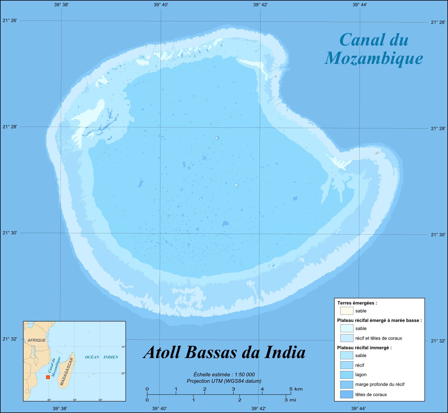
English: Map in French of the French atoll of Bassas da India, Scattered islands in the Indian Ocean.
Français : Carte en français de l'atoll français de Bassas da India, Îles Éparses.
|
||
| Date | |||
| Source |
Own work |
||
| Author | Eric Gaba (Sting - fr:Sting) | ||
| Permission (Reusing this file) |
|
||
| Other versions |
[]
|


Licensing edit
I, the copyright holder of this work, hereby publish it under the following licenses:

|
Permission is granted to copy, distribute and/or modify this document under the terms of the GNU Free Documentation License, Version 1.2 or any later version published by the Free Software Foundation; with no Invariant Sections, no Front-Cover Texts, and no Back-Cover Texts. A copy of the license is included in the section entitled GNU Free Documentation License. |
This file is licensed under the Creative Commons Attribution-Share Alike 4.0 International, 3.0 Unported, 2.5 Generic, 2.0 Generic and 1.0 Generic license.
- You are free:
- to share – to copy, distribute and transmit the work
- to remix – to adapt the work
- Under the following conditions:
- attribution – You must give appropriate credit, provide a link to the license, and indicate if changes were made. You may do so in any reasonable manner, but not in any way that suggests the licensor endorses you or your use.
- share alike – If you remix, transform, or build upon the material, you must distribute your contributions under the same or compatible license as the original.
You may select the license of your choice.
File history
Click on a date/time to view the file as it appeared at that time.
| Date/Time | Thumbnail | Dimensions | User | Comment | |
|---|---|---|---|---|---|
| current | 13:51, 19 July 2010 | | 1,555 × 1,435 (371 KB) | Sting (talk | contribs) | Color profile |
| 15:30, 17 November 2009 |  | 1,555 × 1,435 (373 KB) | Sting (talk | contribs) | Embedded sRGB profile | |
| 17:59, 6 June 2008 |  | 1,555 × 1,435 (329 KB) | Sting (talk | contribs) | Inkscape export bug correction | |
| 17:40, 6 June 2008 |  | 1,555 × 1,435 (331 KB) | Sting (talk | contribs) | == Summary == {{Location|21|28|39|S|39|41|07|E|scale:100000}} <br/>{{Information |Description={{en|Map in French of the French atoll of Bassas da India, [[:en:Scattered islands in the Indian Ocean|Scattered islands in the Indian Oc |
You cannot overwrite this file.
File usage on Commons
The following 7 pages use this file:
File usage on other wikis
The following other wikis use this file:
- Usage on ar.wikipedia.org
- Usage on ast.wikipedia.org
- Usage on ca.wikipedia.org
- Usage on ceb.wikipedia.org
- Usage on en.wikipedia.org
- Usage on eo.wikipedia.org
- Usage on es.wikipedia.org
- Usage on eu.wikipedia.org
- Usage on fr.wikipedia.org
- Usage on mg.wikipedia.org
- Usage on mk.wikipedia.org
- Usage on pl.wikipedia.org
- Usage on pt.wikipedia.org
- Usage on ro.wikipedia.org
- Usage on sq.wikipedia.org
- Usage on sv.wikipedia.org
- Usage on tr.wikipedia.org
- Usage on uk.wikipedia.org
- Usage on ur.wikipedia.org
- Usage on vi.wikipedia.org
- Usage on www.wikidata.org
- Usage on zh.wikipedia.org