File:Bataille navale des Dardanelles 1915 carte ancienne.jpg
Size of this preview: 480 × 600 pixels. Other resolutions: 192 × 240 pixels | 384 × 480 pixels.
Original file (800 × 1,000 pixels, file size: 140 KB, MIME type: image/jpeg)
Captions
Captions
Add a one-line explanation of what this file represents
Summary edit
| Description |
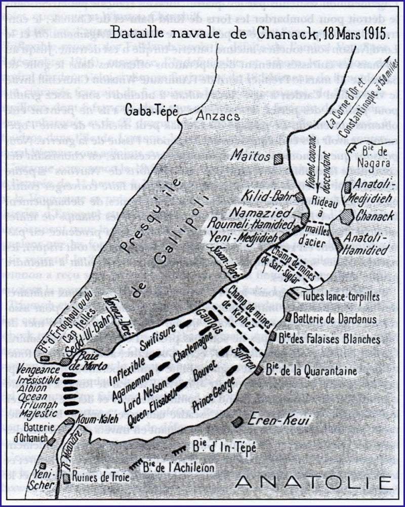
Français : Carte de l'attaque navale franco-anglaise contre le détroit des Dardanelles le 18 mars 1915 avec position des navires alliés, des forts et des champs de mines turcs. Carte sans date précise, probablement vers 1920.
English: Map of the Franco-British naval attack on the Dardanelles on March 18, 1915 with positions of Allied ships, forts and Turkish minefields. Map without precise date, probably around 1920. |
| Date | between 1915 and 1920 |
| Source | maquetland.com |
| Author | Unknown author |
Licensing edit
This media file is in the public domain in the United States. This applies to U.S. works where the copyright has expired, often because its first publication occurred prior to January 1, 1929, and if not then due to lack of notice or renewal. See this page for further explanation.
|
 | |
 |
This image might not be in the public domain outside of the United States; this especially applies in the countries and areas that do not apply the rule of the shorter term for US works, such as Canada, Mainland China (not Hong Kong or Macao), Germany, Mexico, and Switzerland. The creator and year of publication are essential information and must be provided. See Wikipedia:Public domain and Wikipedia:Copyrights for more details.
|
File history
Click on a date/time to view the file as it appeared at that time.
| Date/Time | Thumbnail | Dimensions | User | Comment | |
|---|---|---|---|---|---|
| current | 08:55, 28 April 2014 | | 800 × 1,000 (140 KB) | AYE R (talk | contribs) | User created page with UploadWizard |
You cannot overwrite this file.
File usage on Commons
There are no pages that use this file.
File usage on other wikis
The following other wikis use this file: