File:Battle Plan Canton.jpg

Size of this preview: 800 × 356 pixels. Other resolutions: 320 × 142 pixels | 640 × 285 pixels | 1,328 × 591 pixels.
Original file (1,328 × 591 pixels, file size: 149 KB, MIME type: image/jpeg)
Captions
Captions
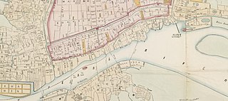
Battle plan of the first battle of Canton (1856)
Summary
edit| Description |
English: Zoom on Canton extracted from "Map of the City and Entire Suburbs of Canton in 1860 by Rev. D. Vrooman" |
||||||||||||||||
| Date | |||||||||||||||||
| Source |
http://www.nla.gov.au/apps/cdview/nla.map-lms636 |
||||||||||||||||
| Author |
|
||||||||||||||||

Licensing
edit
|
This work is in the public domain in its country of origin and other countries and areas where the copyright term is the author's life plus 70 years or fewer. This work is in the public domain in the United States because it was published (or registered with the U.S. Copyright Office) before January 1, 1929. | |
| This file has been identified as being free of known restrictions under copyright law, including all related and neighboring rights. | |
File history
Click on a date/time to view the file as it appeared at that time.
| Date/Time | Thumbnail | Dimensions | User | Comment | |
|---|---|---|---|---|---|
| current | 13:30, 19 May 2020 | | 1,328 × 591 (149 KB) | ManuRoquette (talk | contribs) | Uploaded a work by {{Creator:Daniel Vrooman}} from {{Extracted from|1=Canton1860.jpg}} with UploadWizard |
You cannot overwrite this file.
File usage on Commons
The following page uses this file:
File usage on other wikis
The following other wikis use this file:
- Usage on fr.wikipedia.org