File:Battle of Chippawa, Historic Sites and Monuments Board of Canada, Between Fort Erie and Niagara Falls, Ontario (29358740893).jpg
Size of this preview: 800 × 600 pixels. Other resolutions: 320 × 240 pixels | 640 × 480 pixels | 1,024 × 768 pixels | 1,280 × 960 pixels | 2,560 × 1,920 pixels | 4,000 × 3,000 pixels.
Original file (4,000 × 3,000 pixels, file size: 3.38 MB, MIME type: image/jpeg)
Captions
Captions
Add a one-line explanation of what this file represents
Summary
edit.jpg&action=edit§ion=1)
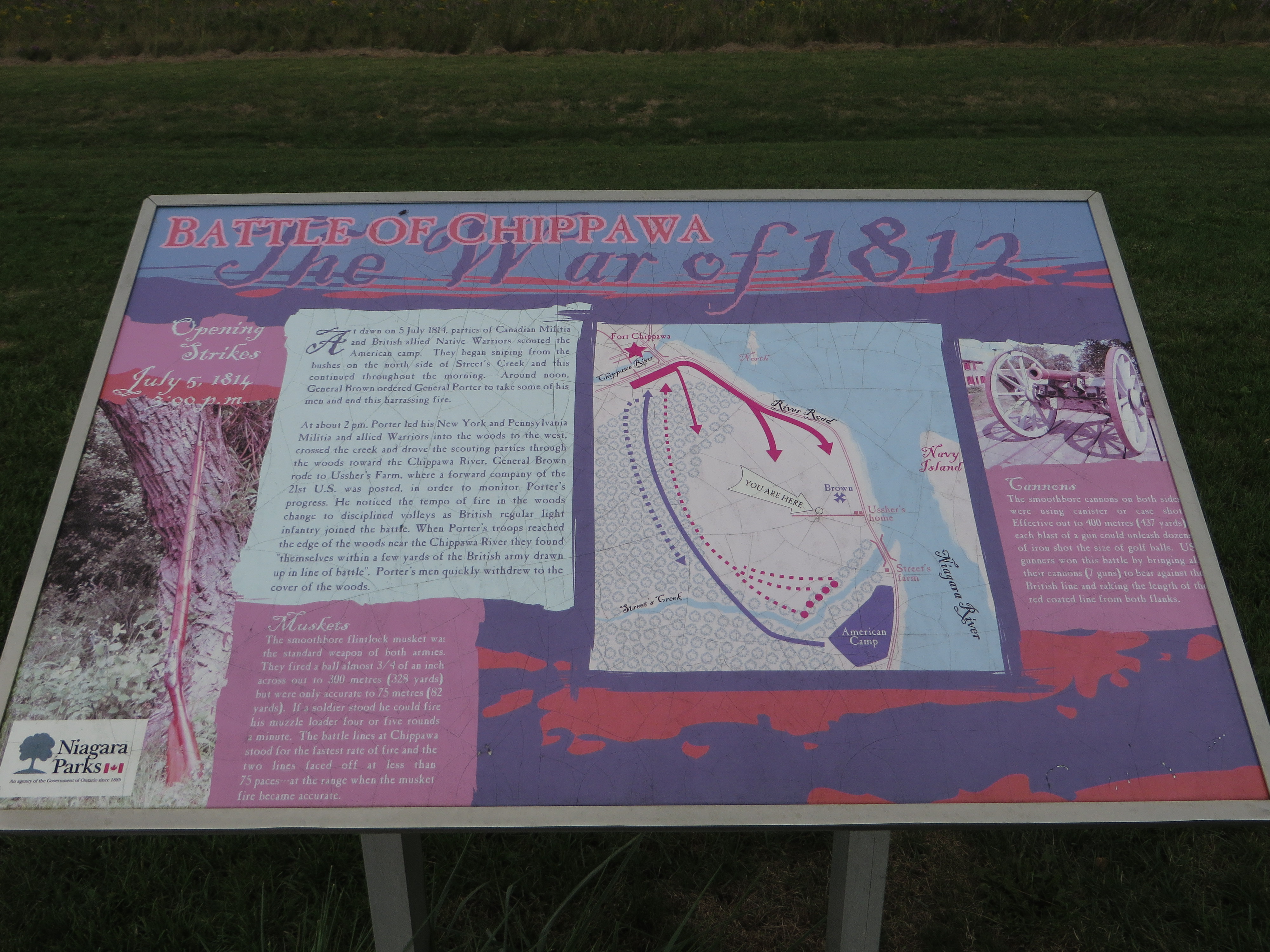
| Description | At dawn 5 July 1814, parties of Canadian-Militia and British allied Native Warriors scouted the American camp. They began sniping from the bushes on the north side of Street’s Creek and this continued throughout the morning. Around noon, General Brown ordered General Porter to take some of his men and end this harassing fire. At about 2pm, Porter led his New York and Pennsylvania Militia and allied Warriors into the woods to the west, crossed the creek and drove the scouting parties through the woods towards the Chippawa River. General Brown rode to Ussher’s Farm, where a forward company of the 21st U.S. was posted, in order to monitor Porter’s progress. He noticed the tempo of fire in the woods change to disciplined volleys as British regular light infantry joined the battle. When Porter’s troops reached the edge of the woods near the Chippawa River they found themselves within a few yards of the British army drawn up in the line of battle. Porter’s men quickly withdrew to the cover of the woods. Muskets The smoothbore flintlock musket was the standard weapon of both armies. They fired a ball almost 3/4 of an inch across out to 300 meters (328 yards) but were only accurate to 75 meters (82 yards). If a soldier stood he could fire his muzzle loader four or five rounds a minute. The battle lines at Chippawa stood for the fastest rate of fire and the two lines faced off at less than 75 paces at the range when the musket fire becomes accurate. Cannons The smoothbore cannons on both sides were using canister or case shot. Effective out to 400 meters (437 yards) each blast of a gun could unleash dozens of iron shot the size of golf balls. U.S. gunners won this battle by bringing their cannons (7 guns) against the British line and raking the length of the red coated line from both flanks. |
| Date | |
| Source | Battle of Chippawa, Historic Sites and Monuments Board of Canada, Between Fort Erie and Niagara Falls, Ontario |
| Author | Ken Lund from Reno, Nevada, USA |
| Camera location | | View this and other nearby images on: OpenStreetMap |
|---|
.jpg¶ms=043.052294_N_-079.024664_E_globe:Earth_type:camera_source:Flickr_&language=en)
Licensing
edit.jpg&action=edit§ion=2)
This file is licensed under the Creative Commons Attribution-Share Alike 2.0 Generic license.
- You are free:
- to share – to copy, distribute and transmit the work
- to remix – to adapt the work
- Under the following conditions:
- attribution – You must give appropriate credit, provide a link to the license, and indicate if changes were made. You may do so in any reasonable manner, but not in any way that suggests the licensor endorses you or your use.
- share alike – If you remix, transform, or build upon the material, you must distribute your contributions under the same or compatible license as the original.
| This image was originally posted to Flickr by Ken Lund at https://flickr.com/photos/75683070@N00/29358740893. It was reviewed on 10 March 2022 by FlickreviewR 2 and was confirmed to be licensed under the terms of the cc-by-sa-2.0. |
File history
Click on a date/time to view the file as it appeared at that time.
| Date/Time | Thumbnail | Dimensions | User | Comment | |
|---|---|---|---|---|---|
| current | 19:21, 10 March 2022 | | 4,000 × 3,000 (3.38 MB) | Mindmatrix (talk | contribs) | Transferred from Flickr via #flickr2commons |
You cannot overwrite this file.
File usage on Commons
There are no pages that use this file.
.jpg&oldid=818657373)