File:Battle of Chippawa, Historic Sites and Monuments Board of Canada, Between Fort Erie and Niagara Falls, Ontario (29985412345).jpg

Size of this preview: 800 × 600 pixels. Other resolutions: 320 × 240 pixels | 640 × 480 pixels | 1,024 × 768 pixels | 1,280 × 960 pixels | 2,560 × 1,920 pixels | 4,000 × 3,000 pixels.
Original file (4,000 × 3,000 pixels, file size: 3.19 MB, MIME type: image/jpeg)
Captions
Captions
Add a one-line explanation of what this file represents
Summary
edit.jpg&action=edit§ion=1)
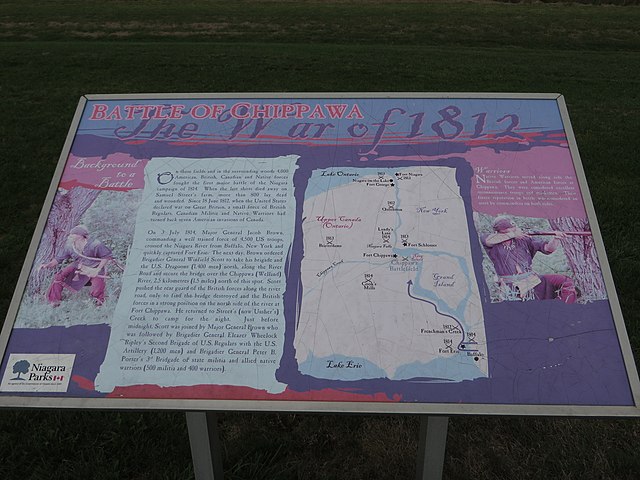
| Description | On these fields and the surrounding woods 4,000 American, British, Canadian and Native forces fought the first major battle of the Niagara campaign of 1814. When the last shots died away on Samuel Street’s farm, more than 800 lay dead and wounded. Since 18 June 1812, when the United States declared war on Great Britain, a small force of British Regulars, Canadian Militia and Native Warriors had turned back seven American invasions of Canada. On 3 July 1814, Major General Jacob Brown, commanding a well trained force of 4,500 troops, crossed the Niagara River from Buffalo, New York and quickly captured Fort Erie. The next day, Brown ordered Brigadier General Winfield Scott to take his brigade and the U.S. Dragoons (1400 men) north, along the River Road and secure the bridge over the Chippawa (Welland) River, 2.5 kilometres (1.5 miles) north of this spot. Scott pushed the rear guard of the British forces along the river road, only to find the bridge destroyed and the British forces in a strong position on the north side of the river at Fort Chippawa. He returned to Street’s (now Ussher’s) Creek to camp for the night. Just before midnight, Scott was joined by Major General Brown who was followed by Brigadier General Eleazer Wheelock Ripley’s Second Brigade of U.S. Regulars with the U.S. Artillery (1,200 men) and Brigadier General Peter B. Porter’s 3rd Brigade of state militia and allied native warriors (500 militia and 400 warriors). Native Warriors served along side the British forces and American forces at Chippawa. They were considered excellent reconnaissance troops and marksmen. Their fierce reputation in battle was considered an asset by commanders on both sides. |
| Date | |
| Source | Battle of Chippawa, Historic Sites and Monuments Board of Canada, Between Fort Erie and Niagara Falls, Ontario |
| Author | Ken Lund from Reno, Nevada, USA |
| Camera location | | View this and other nearby images on: OpenStreetMap |
|---|
.jpg¶ms=043.052274_N_-079.024739_E_globe:Earth_type:camera_source:Flickr_&language=en)
Licensing
edit.jpg&action=edit§ion=2)
This file is licensed under the Creative Commons Attribution-Share Alike 2.0 Generic license.
- You are free:
- to share – to copy, distribute and transmit the work
- to remix – to adapt the work
- Under the following conditions:
- attribution – You must give appropriate credit, provide a link to the license, and indicate if changes were made. You may do so in any reasonable manner, but not in any way that suggests the licensor endorses you or your use.
- share alike – If you remix, transform, or build upon the material, you must distribute your contributions under the same or compatible license as the original.
| This image was originally posted to Flickr by Ken Lund at https://flickr.com/photos/75683070@N00/29985412345. It was reviewed on 10 March 2022 by FlickreviewR 2 and was confirmed to be licensed under the terms of the cc-by-sa-2.0. |
File history
Click on a date/time to view the file as it appeared at that time.
| Date/Time | Thumbnail | Dimensions | User | Comment | |
|---|---|---|---|---|---|
| current | 19:21, 10 March 2022 | | 4,000 × 3,000 (3.19 MB) | Mindmatrix (talk | contribs) | Transferred from Flickr via #flickr2commons |
You cannot overwrite this file.
File usage on Commons
There are no pages that use this file.
.jpg&oldid=897496239)