File:Battle of Fayetteville Virginia 1862.png

Size of this preview: 693 × 599 pixels. Other resolutions: 278 × 240 pixels | 555 × 480 pixels | 923 × 798 pixels.
Original file (923 × 798 pixels, file size: 1.65 MB, MIME type: image/png)
Captions
Captions
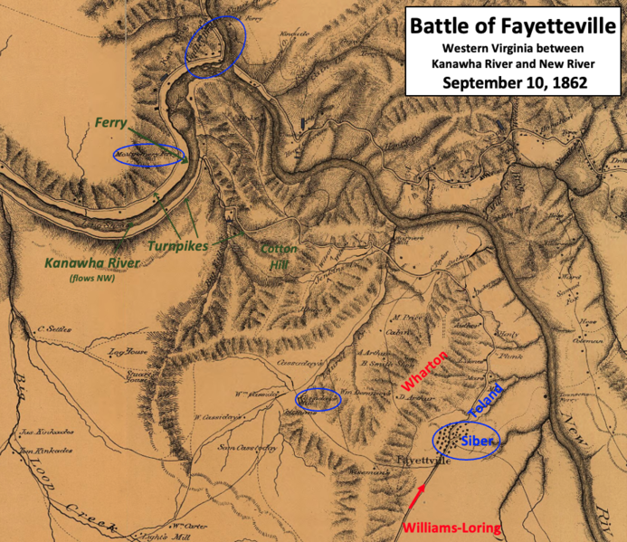
Siber was surrounded by a larger Confederate force
Summary
edit
| Description |
English: This map shows the situation on September 10, 1862, near Fayetteville, Virginia (now West Virginia), during the American Civil War. Union Colonel Siber was nearly surrounded by a larger Confederate force commanded by Major General William W. Loring, but Siber's position was behind fortifications. |
| Date | |
| Source | This is a military reconnaissance map of the vicinity of Gauley Bridge in western Virginia as of 1861. The map has been altered by TwoScarsUp to remove notations for 1861 and add information for 1862, based on information provided in chapter 4 of the book "The Battle of Charleston and the 1862 Kanawha Valley Campaign" by Terry Lowry. The original map can be found at the U.S. Library of Congress here. |
| Author | Office of the Chief of Engineers, U.S. Army, William Franklin Rayolds (1820-1894) modified by TwoScarsUp |
Western Virginia (now West Virginia) between the New River and the Kanawha River, with mountainous terrain
Licensing
edit
This work is in the public domain in the United States because it is a work prepared by an officer or employee of the United States Government as part of that person’s official duties under the terms of Title 17, Chapter 1, Section 105 of the US Code.
Note: This only applies to original works of the Federal Government and not to the work of any individual U.S. state, territory, commonwealth, county, municipality, or any other subdivision. This template also does not apply to postage stamp designs published by the United States Postal Service since 1978. (See § 313.6(C)(1) of Compendium of U.S. Copyright Office Practices). It also does not apply to certain US coins; see The US Mint Terms of Use.
|
 | |
| This file has been identified as being free of known restrictions under copyright law, including all related and neighboring rights. | ||
File history
Click on a date/time to view the file as it appeared at that time.
| Date/Time | Thumbnail | Dimensions | User | Comment | |
|---|---|---|---|---|---|
| current | 21:51, 2 December 2022 | | 923 × 798 (1.65 MB) | TwoScarsUp (talk | contribs) | Uploaded a work by Office of the Chief of Engineers, U.S. Army, William Franklin Rayolds (1820-1894) modified by TwoScarsUp from This is a military reconnaissance map of the vicinity of Gauley Bridge in western Virginia as of 1861. The map has been altered by TwoScarsUp to remove notations for 1861 and add information for 1862, based on information provided in chapter 4 of the book "The Battle of Charleston and the 1862 Kanawha Valley Campaign" by Terry Lowry. The original map can be found at... |
You cannot overwrite this file.
File usage on Commons
There are no pages that use this file.
File usage on other wikis
The following other wikis use this file:
- Usage on en.wikipedia.org