File:Battle of Hill 70 - local planning map.jpg

Size of this preview: 800 × 579 pixels. Other resolutions: 320 × 232 pixels | 640 × 463 pixels | 1,024 × 741 pixels | 1,280 × 927 pixels | 2,560 × 1,854 pixels | 21,871 × 15,837 pixels.
Original file (21,871 × 15,837 pixels, file size: 42.02 MB, MIME type: image/jpeg)
Captions
Captions
Add a one-line explanation of what this file represents
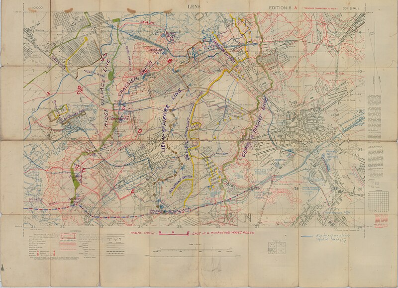
| Description | High Resolution Local Planning Map [1:10,000]. Light linen backing. Trenches corrected to 10-02-17. Disclaimer regardig obstacles, water features in blue.Contours and water features show in colour. Extensive amount of annotation regarding roads, railways, defensive lines, boundaries, locations of defensive positions, new construction and destroyed bridges. Sheet numbers: 36c SW1 | |||||||||
| Date | Produced 10-02-17 | |||||||||
| Source |
McMaster University, Fonds: WW1 Trench Maps: France, Box no. 6, envelope no. 188, database no. 123 Online: http://lt1.mcmaster.ca/ww1/wrz4mp.php?grid=57c&map_id=123 |
|||||||||
| Author | Field Service Battalion, Royal Engineers | |||||||||
| Permission (Reusing this file) |
|

File history
Click on a date/time to view the file as it appeared at that time.
| Date/Time | Thumbnail | Dimensions | User | Comment | |
|---|---|---|---|---|---|
| current | 23:15, 19 February 2024 | | 21,871 × 15,837 (42.02 MB) | Labattblueboy (talk | contribs) | higher resoluton of same file |
| 14:30, 8 June 2009 |  | 5,468 × 3,959 (2.87 MB) | Labattblueboy (talk | contribs) | {{Information |Description= High Resolution Local Planning Map [1:10,000]. Light linen backing. Trenches corrected to 10-02-17. Disclaimer regardig obstacles, water features in blue.Contours and water features show in colour. Extensive amount of annotatio |
You cannot overwrite this file.
File usage on Commons
There are no pages that use this file.
File usage on other wikis
The following other wikis use this file:
- Usage on en.wikipedia.org