File:Battle of Saint-Martin-de-Ré, Île d’Oléron, Île de Ré and La Rochelle, 1625 RCIN 722019.a.jpg

Original file (2,091 × 2,250 pixels, file size: 1.83 MB, MIME type: image/jpeg)
Captions
Captions
Summary edit
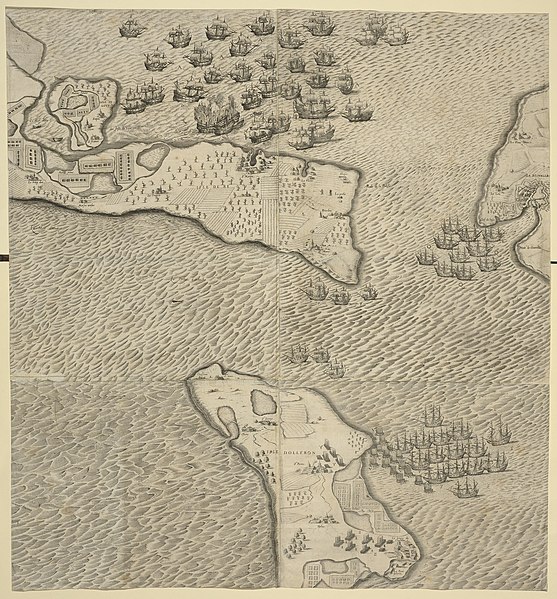
| Français : L’ARMEE NAVALE DES HVGVENOTS REBELLES ENTIEREMENT DEFAITE PAR MONSIEVR de Montmorancy Admiral de France, auec la descente qu’il fit faire en l’Isle d’Oleron le 17. Septembre 1625. TROISIESME IOVRNEE.
( |
|||||||||||||||||||||
|---|---|---|---|---|---|---|---|---|---|---|---|---|---|---|---|---|---|---|---|---|---|
| Author |
N. Du Carlo (fl.1625) (draughtsman) French Military Engineer After Charles Leber (draughtsman) Melchior Tavernier (1594-1665) (publisher) |
||||||||||||||||||||
| Title |
Français : L’ARMEE NAVALE DES HVGVENOTS REBELLES ENTIEREMENT DEFAITE PAR MONSIEVR de Montmorancy Admiral de France, auec la descente qu’il fit faire en l’Isle d’Oleron le 17. Septembre 1625. TROISIESME IOVRNEE. |
||||||||||||||||||||
| Description |
English: A middle/high oblique view/map of the third day of the naval Battle of Saint-Martin de Ré, fought on 17 September 1625, showing the taking of the Île d'Oléron by the French Catholic forces. (See RCIN 722017 for further details.) Huguenot Rebellions or Rohan Wars (1625). Oriented with north to top.
see RCIN 722019.b for a description of the separate accompanying letterpress text. George III catalogue entry: Ré L’Armée Navale des Huguenots Rebelles entierement defaite par l’Admiral de Montmorancy avec la descente qu’il fit faire en l’Isle d’Oleron le 17 Sept.re 1625: par Ducarlo Ing.r chez Tavernier. 4 feuilles. |
||||||||||||||||||||
| Depicted place |
Saint-Martin-de-Ré, Poitou-Charentes, France (46°12ʹ11ʺN 01°22ʹ02ʺW) Île d’Oléron, Poitou-Charentes, France (45°56ʹ00ʺN 01°18ʹ00ʺW) Île de Ré, Poitou-Charentes, France(46°12ʹ00ʺN 01°25ʹ00ʺE) La Rochelle, Poitou-Charentes, France(46°10ʹ00ʺN 01°09ʹ00ʺW) |
||||||||||||||||||||
| Date | 1625 | ||||||||||||||||||||
| Medium | etching print | ||||||||||||||||||||
| Dimensions | 76.6 x 71.1 cm (image and sheet) | ||||||||||||||||||||
| Collection |
|
||||||||||||||||||||
| Accession number |
RCIN 722019.a |
||||||||||||||||||||
| Source/Photographer | https://militarymaps.rct.uk/other-17th-century-conflicts/battle-of-saint-martin-de-re-ile-doleron-ile-de-re | ||||||||||||||||||||
| Other versions |
|
||||||||||||||||||||

Licensing edit
|
This is a faithful photographic reproduction of a two-dimensional, public domain work of art. The work of art itself is in the public domain for the following reason:
The official position taken by the Wikimedia Foundation is that "faithful reproductions of two-dimensional public domain works of art are public domain".
This photographic reproduction is therefore also considered to be in the public domain in the United States. In other jurisdictions, re-use of this content may be restricted; see Reuse of PD-Art photographs for details. | ||||
File history
Click on a date/time to view the file as it appeared at that time.
| Date/Time | Thumbnail | Dimensions | User | Comment | |
|---|---|---|---|---|---|
| current | 19:57, 6 August 2021 | | 2,091 × 2,250 (1.83 MB) | Broichmore (talk | contribs) | {{Artwork |author= N. Du Carlo (fl.1625) (draughtsman) French Military Engineer After Charles Leber (draughtsman) Melchior Tavernier (1594-1665) (publisher) |title= {{fr|1=L’ARMEE NAVALE DES HVGVENOTS REBELLES ENTIEREMENT DEFAITE PAR MONSIEVR de Montmorancy Admiral de France, auec la descente qu’il fit faire en l’Isle d’Oleron le 17. Septembre 1625. TROISIESME IOVRNEE.}} |description={{en|1=A middle/high oblique view/map of the third day of the naval Battle of Saint-Martin de Ré, fought on... |
You cannot overwrite this file.
File usage on Commons
The following page uses this file: