File:Battle of Tory Island.png
No higher resolution available.
Battle_of_Tory_Island.png (399 × 556 pixels, file size: 18 KB, MIME type: image/png)
Captions
Captions
Add a one-line explanation of what this file represents
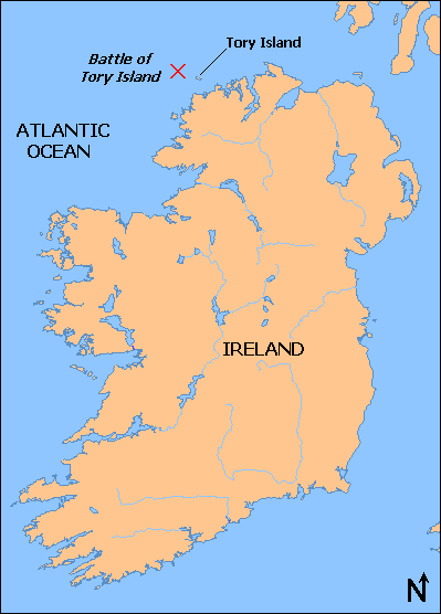
| Description | Map of the location of the Battle of Tory Island, of the coast of County Donegal, Ireland map |
| Date | |
| Source | Base map from OMC, (which uses GMT,[1] an open source software licensed under GNU GPL[2]), modified by myself with the battle location from User:Jackyd101 and other version map |
| Author | Ruhrfisch |
| Permission (Reusing this file) |
GFDL |
| Other versions | Image:Battle of tory island location.png |

|
File:Battle of Tory Island.svg is a vector version of this file. It should be used in place of this PNG file when not inferior.
File:Battle of Tory Island.png → File:Battle of Tory Island.svg
For more information, see Help:SVG. |
 |

|
Permission is granted to copy, distribute and/or modify this document under the terms of the GNU Free Documentation License, Version 1.2 or any later version published by the Free Software Foundation; with no Invariant Sections, no Front-Cover Texts, and no Back-Cover Texts. A copy of the license is included in the section entitled GNU Free Documentation License. |
| This file is licensed under the Creative Commons Attribution-Share Alike 3.0 Unported license. | ||
| ||
| This licensing tag was added to this file as part of the GFDL licensing update. |
File history
Click on a date/time to view the file as it appeared at that time.
| Date/Time | Thumbnail | Dimensions | User | Comment | |
|---|---|---|---|---|---|
| current | 21:06, 11 April 2008 | | 399 × 556 (18 KB) | Ruhrfisch (talk | contribs) | Made Tory Island clearer, line to it slightly shorter, all other inforamtion the same |
| 21:01, 11 April 2008 |  | 399 × 556 (18 KB) | Ruhrfisch (talk | contribs) | {{Information |Description=Map of the location of the Battle of Tory Island, of the coast of County Donegal, Ireland map |Source= Base map from [http://www.aquarius.geomar.de/omc/make_map.html OMC], modified by myself with the battle location from [[User |
You cannot overwrite this file.
File usage on Commons
There are no pages that use this file.