File:Baye de la Delaware avec les ports, sondes, dangers, bancs, etc. depuis les caps jusqu'a Philadelphie d'après la carte de Joshua Fisher publie a Philadelfia, à la Havana, Chéz de Moun̂oz, rue du LOC 74691702.jpg

Size of this preview: 800 × 564 pixels. Other resolutions: 320 × 226 pixels | 640 × 452 pixels | 1,024 × 722 pixels | 1,280 × 903 pixels | 2,560 × 1,806 pixels | 11,052 × 7,797 pixels.
Original file (11,052 × 7,797 pixels, file size: 9.09 MB, MIME type: image/jpeg)
Captions
Captions
Add a one-line explanation of what this file represents
Summary edit
| Warning | The original file is very high-resolution. It might not load properly or could cause your browser to freeze when opened at full size. |
|---|
| Description |
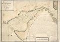
English: Scale ca. 1:200,000. Manuscript, pen-and-ink, and watercolor. Depths shown in fathoms. Oriented with north to the right. Place names in English. Copied from Georges Louis LeRouge's Pilote américain septentrional. 1778. v. 1, pl. no. 14. Includes "Direcctions pour monter la baye de Delaware" and inset. LC Maps of North America, 1750-1789, 1364 LC Luso-Hispanic World, 818 Available also through the Library of Congress Web site as a raster image. Vault AACR2: 100; 650/1; 651/2; 650/3; 651/4; 700/1; 700/2 |
||
| Title | Baye de la Delaware avec les ports, sondes, dangers, bancs, &c. depuis les caps jusqu'a Philadelphie d'après la carte de Joshua Fisher publie a Philadelfia, à la Havana, Chéz de Moun̂oz, rue du Soléille, 1785, 1777. | ||
| Shelf ID | G3832.D4P5 1777 .Y3 | ||
| Date | |||
| Source | https://www.loc.gov/item/74691702/ | ||
| Author | Ybarra; Fisher, Joshua; Le Rouge, Georges-Louis; Moun̂Oz (Firm) | ||
| Permission (Reusing this file) |
|
||
| Other versions |
|
||
| Location | Delaware · New Jersey · Delaware Bay · United States · Pennsylvania · Delaware River · New York | ||
| Part of | Military Battles And Campaigns · American Memory · Catalog · Geography And Map Division · American Revolution And Its Era: Maps And Charts Of North America And The West Indies, 1750-1789 | ||
| Subject | Maps, Manuscript · Delaware Bay · Delaware River (N.Y.-Del. And N.J.) · New Jersey · Delaware · Nautical Charts · Delaware Bay (Del. And N.J.) · United States · Pennsylvania · Early Works To 1800 · Delaware River |

Licensing edit
|
This is a faithful photographic reproduction of a two-dimensional, public domain work of art. The work of art itself is in the public domain for the following reason:
The official position taken by the Wikimedia Foundation is that "faithful reproductions of two-dimensional public domain works of art are public domain".
This photographic reproduction is therefore also considered to be in the public domain in the United States. In other jurisdictions, re-use of this content may be restricted; see Reuse of PD-Art photographs for details. | ||||
File history
Click on a date/time to view the file as it appeared at that time.
| Date/Time | Thumbnail | Dimensions | User | Comment | |
|---|---|---|---|---|---|
| current | 22:01, 18 May 2018 | | 11,052 × 7,797 (9.09 MB) | Fæ (talk | contribs) | LOC Maps https://www.loc.gov/item/74691702/ #11015 |
You cannot overwrite this file.
File usage on Commons
The following page uses this file: