File:Becquerel - PIA00171-MC-11-OxiaPalusRegion-19980605 (cropped).jpg

Size of this preview: 604 × 600 pixels. Other resolutions: 242 × 240 pixels | 483 × 480 pixels | 710 × 705 pixels.
Original file (710 × 705 pixels, file size: 45 KB, MIME type: image/jpeg)
Captions
Captions
Add a one-line explanation of what this file represents
Summary edit
| Description |
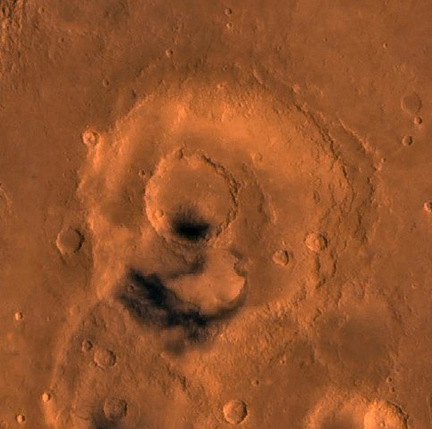
English: PIA00171: MC-11 Oxia Palus Region
Mars digital-image mosaic merged with color of the MC-11 quadrangle, Oxia Palus region of Mars. Heavily cratered highlands of the southeastern two-thirds are cut by several large outflow channels. These channels terminate at the dark large depression, Chryse basin, which contain relatively smooth plains in the northwestern part. Latitude range 0 to 30 degrees, longitude range 0 to 45 degrees. |
| Date | |
| Source | http://photojournal.jpl.nasa.gov/jpeg/PIA00171.jpg |
| Author | NASA/JPL/USGS |
| Other versions |

.jpg&action=edit§ion=1)
Licensing edit
.jpg&action=edit§ion=2)
| This file is in the public domain in the United States because it was solely created by NASA. NASA copyright policy states that "NASA material is not protected by copyright unless noted". (See Template:PD-USGov, NASA copyright policy page or JPL Image Use Policy.) | ||
 |
Warnings:
|
File history
Click on a date/time to view the file as it appeared at that time.
| Date/Time | Thumbnail | Dimensions | User | Comment | |
|---|---|---|---|---|---|
| current | 14:16, 23 February 2018 | | 710 × 705 (45 KB) | Asqueladd (talk | contribs) | File:PIA00171-MC-11-OxiaPalusRegion-19980605.jpg cropped 90 % horizontally and 86 % vertically using CropTool with lossless mode. |
You cannot overwrite this file.
File usage on Commons
The following 3 pages use this file:
File usage on other wikis
The following other wikis use this file:
- Usage on es.wikipedia.org
- Usage on it.wikipedia.org
- Usage on www.wikidata.org
.jpg&oldid=819909002)