File:Belgian Railway Line 25.png
Size of this preview: 800 × 548 pixels. Other resolutions: 320 × 219 pixels | 640 × 438 pixels | 1,024 × 701 pixels | 1,280 × 877 pixels | 1,546 × 1,059 pixels.
Original file (1,546 × 1,059 pixels, file size: 2.5 MB, MIME type: image/png)
Captions
Captions
Add a one-line explanation of what this file represents
Summary
edit
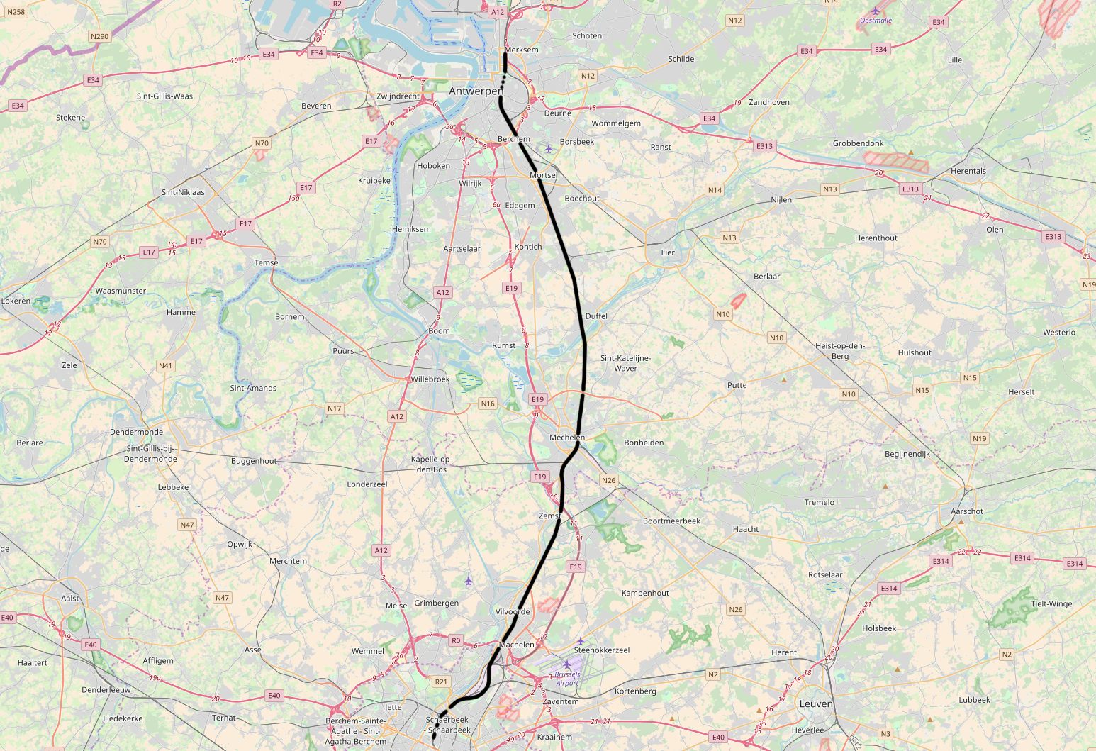
| Description | Belgian Railway Line 25, Brussel-Noord - Antwerpen-Luchtbal |
| Source | openstreetmap.org, see Relation: 57979 from the OpenStreetMap Belgium/Railways project. |
| Author | OpenStreetMap contributors |
| Permission (Reusing this file) |
All OpenStreetMap data and maps are Creative Commons "CC-BY-SA 2.0" licensed |
Licensing
edit
This file is licensed under the Creative Commons Attribution-Share Alike 2.0 Generic license.
- You are free:
- to share – to copy, distribute and transmit the work
- to remix – to adapt the work
- Under the following conditions:
- attribution – You must give appropriate credit, provide a link to the license, and indicate if changes were made. You may do so in any reasonable manner, but not in any way that suggests the licensor endorses you or your use.
- share alike – If you remix, transform, or build upon the material, you must distribute your contributions under the same or compatible license as the original.
File history
Click on a date/time to view the file as it appeared at that time.
| Date/Time | Thumbnail | Dimensions | User | Comment | |
|---|---|---|---|---|---|
| current | 11:22, 11 November 2017 | | 1,546 × 1,059 (2.5 MB) | Vunz (talk | contribs) | fix |
| 09:54, 14 May 2014 |  | 1,489 × 1,111 (2.85 MB) | Vunz (talk | contribs) | improved | |
| 15:24, 2 September 2010 |  | 1,065 × 772 (1.33 MB) | Vunz (talk | contribs) | ||
| 08:07, 26 October 2009 |  | 1,065 × 772 (1.33 MB) | Vunz (talk | contribs) | Reverted to version as of 13:23, 24 September 2009 - Expanded much better, former lines not correct | |
| 12:49, 18 October 2009 |  | 520 × 390 (41 KB) | Wester (talk | contribs) | Kaartje is ten eerste te druk voor de infobox, ten twede staan de voormalige spoorlijnen er niet op. | |
| 13:23, 24 September 2009 |  | 1,065 × 772 (1.33 MB) | Vunz (talk | contribs) | Open Street Map Category:Rail transport maps of Belgium | |
| 17:53, 4 January 2009 |  | 520 × 390 (41 KB) | Vunz (talk | contribs) | extended to Antwerpen-Luchtbal Category:Public domain maps from demis.nl Category:Rail transport maps of Belgium | |
| 20:47, 17 March 2007 |  | 640 × 480 (60 KB) | Arafi (talk | contribs) | {{Information |Description=Schematische voorstelling van de spoorlijn 25 in België |Source=eigen werk (gebaseerd op http://www.demis.nl/wms/mapclip.htm) |Date=17 maart 2007 |Author='''Rafaël Delaedt''' (Arafi) |Permission={{PD-Demis}} }} |
You cannot overwrite this file.
File usage on Commons
The following 12 pages use this file:
- User:Arafi/Kaarten
- User:Chumwa/OgreBot/Potential transport maps/2017 November 11-20
- User:Chumwa/OgreBot/Public transport information/2017 November 11-20
- User:Chumwa/OgreBot/Transport Maps/2017 November 11-20
- User:Chumwa/OgreBot/Travel and communication maps/2017 November 11-20
- File:Spoorlijn25.png (file redirect)
- Category:Line 25 (Infrabel)
File usage on other wikis
The following other wikis use this file:
- Usage on de.wikipedia.org
- Usage on en.wikipedia.org
- Usage on fr.wikipedia.org
- Usage on it.wikipedia.org
- Usage on ko.wikipedia.org
- Usage on nl.wikipedia.org
- Usage on www.wikidata.org
- Usage on zh.wikipedia.org