File:Belgian federal election 2014 map en.svg

Size of this PNG preview of this SVG file: 800 × 414 pixels. Other resolutions: 320 × 166 pixels | 640 × 331 pixels | 1,024 × 530 pixels | 1,280 × 662 pixels | 2,560 × 1,324 pixels | 2,405 × 1,244 pixels.
Original file (SVG file, nominally 2,405 × 1,244 pixels, file size: 1.13 MB)
Captions
Captions
Add a one-line explanation of what this file represents
Summary edit
| Description |
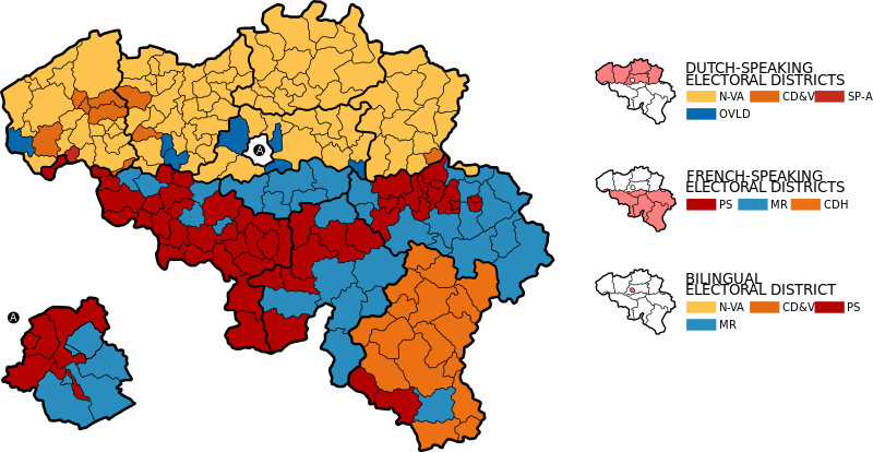
English: Electoral district map of the Belgian general election, 2014. Winning parties in electoral cantons (thinner line). The eleven Belgian electoral districts are accentuated with a thicker line. The Brussels-Capital electoral district (A) is enlarged.
Deutsch: Wahlkreiskarte zu den Parlamentswahlen in Belgien 2014. Stärkste Partei nach Wahlkanton (dünnere Linie). Die elf belgische Wahlkreise sind durch eine dickere Linie hervorgehoben. Der Wahlkreis Brüssel-Hauptstadt (A) ist vergrößert dargestellt. |
| Date | |
| Source | Own work. Based on the informations of the Federal Public Services Home Affairs (2014). |
| Author | KaterBegemot |
Licensing edit
I, the copyright holder of this work, hereby publish it under the following licenses:

|
Permission is granted to copy, distribute and/or modify this document under the terms of the GNU Free Documentation License, Version 1.2 or any later version published by the Free Software Foundation; with no Invariant Sections, no Front-Cover Texts, and no Back-Cover Texts. A copy of the license is included in the section entitled GNU Free Documentation License. |
This file is licensed under the Creative Commons Attribution-Share Alike 3.0 Unported, 2.5 Generic, 2.0 Generic and 1.0 Generic license.
- You are free:
- to share – to copy, distribute and transmit the work
- to remix – to adapt the work
- Under the following conditions:
- attribution – You must give appropriate credit, provide a link to the license, and indicate if changes were made. You may do so in any reasonable manner, but not in any way that suggests the licensor endorses you or your use.
- share alike – If you remix, transform, or build upon the material, you must distribute your contributions under the same or compatible license as the original.
You may select the license of your choice.
File history
Click on a date/time to view the file as it appeared at that time.
| Date/Time | Thumbnail | Dimensions | User | Comment | |
|---|---|---|---|---|---|
| current | 21:18, 1 August 2014 | | 2,405 × 1,244 (1.13 MB) | KaterBegemot (talk | contribs) | == {{int:filedesc}} == {{Information |Description={{en|1=Electoral district map of the Belgian general election, 2014. Winning parties in electoral cantons (thinner line). The eleven Belgian electoral districts ar... |
You cannot overwrite this file.
File usage on Commons
There are no pages that use this file.
File usage on other wikis
The following other wikis use this file:
- Usage on it.wikipedia.org