File:Benchmark, Station House, Kirkcudbright (geograph 7501274).jpg

Size of this preview: 800 × 600 pixels. Other resolutions: 320 × 240 pixels | 640 × 480 pixels | 1,024 × 768 pixels | 1,280 × 960 pixels | 1,600 × 1,200 pixels.
Original file (1,600 × 1,200 pixels, file size: 832 KB, MIME type: image/jpeg)
Captions
Captions
Add a one-line explanation of what this file represents
Summary
edit.jpg&action=edit§ion=1)
| Description |
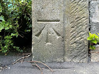
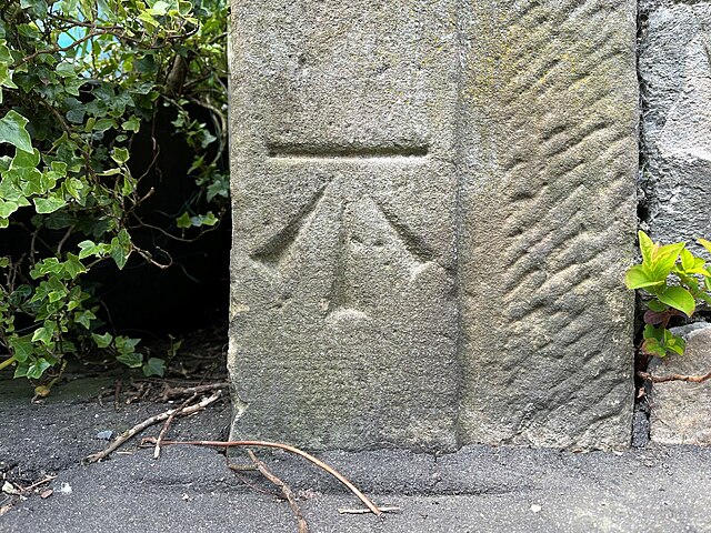
English: Benchmark, Station House, Kirkcudbright Detail of the Ordnance Survey cut benchmark on the south angle of the projection on the south-east face of Station House Cookery School, formerly Kirkcudbright Station. The benchmark marks a height of 7.6941m above mean sea level (Ordnance Datum Newlyn) last levelled and verified in 1971 (location photograph NX6851 : The old station, Kirkcudbright). |
| Date | |
| Source | From geograph.org.uk |
| Author | Adrian Taylor |
| Permission (Reusing this file) |
Creative Commons Attribution Share-alike license 2.0 |
| Attribution (required by the license) | Adrian Taylor / Benchmark, Station House, Kirkcudbright / |
.jpg)
| Camera location | | View this and other nearby images on: OpenStreetMap |
|---|
.jpg¶ms=054.837968_N_-004.047915_E_globe:Earth_type:camera_source:geograph-osgb36(NX6857451161)_heading:292.00&language=en)
| Object location | | View this and other nearby images on: OpenStreetMap |
|---|
.jpg¶ms=054.837970_N_-004.047920_E_globe:Earth_class:object_type:object_source:geograph-osgb36(NX6857451161)_heading:292.00&language=en)
Licensing
edit.jpg&action=edit§ion=2)

|
This image was taken from the Geograph project collection. See this photograph's page on the Geograph website for the photographer's contact details. The copyright on this image is owned by Adrian Taylor and is licensed for reuse under the Creative Commons Attribution-ShareAlike 2.0 license.
|
This file is licensed under the Creative Commons Attribution-Share Alike 2.0 Generic license.
Attribution: Adrian Taylor
- You are free:
- to share – to copy, distribute and transmit the work
- to remix – to adapt the work
- Under the following conditions:
- attribution – You must give appropriate credit, provide a link to the license, and indicate if changes were made. You may do so in any reasonable manner, but not in any way that suggests the licensor endorses you or your use.
- share alike – If you remix, transform, or build upon the material, you must distribute your contributions under the same or compatible license as the original.
File history
Click on a date/time to view the file as it appeared at that time.
| Date/Time | Thumbnail | Dimensions | User | Comment | |
|---|---|---|---|---|---|
| current | 14:10, 24 November 2023 | | 1,600 × 1,200 (832 KB) | Lamberhurst (talk | contribs) | == {{int:filedesc}} == {{Information |Description={{en|1=<b>Benchmark, Station House, Kirkcudbright</b><br>Detail of the Ordnance Survey cut benchmark on the south angle of the projection on the south-east face of Station House Cookery School, formerly Kirkcudbright Station. The benchmark marks a height of 7.6941m above mean sea level (Ordnance Datum Newlyn) last levelled and verified in 1971 (location photograph [[:File:The old station, Kirkcudbright (geograph 7500880).jpg|NX6851 : The old s... |
You cannot overwrite this file.
File usage on Commons
The following page uses this file:
.jpg&oldid=825136014)