File:Bennu global mosaic reduced size.png

Size of this preview: 800 × 400 pixels. Other resolutions: 320 × 160 pixels | 640 × 320 pixels | 1,024 × 512 pixels | 1,280 × 640 pixels | 2,400 × 1,200 pixels.
Original file (2,400 × 1,200 pixels, file size: 4.82 MB, MIME type: image/png)
Captions
Captions
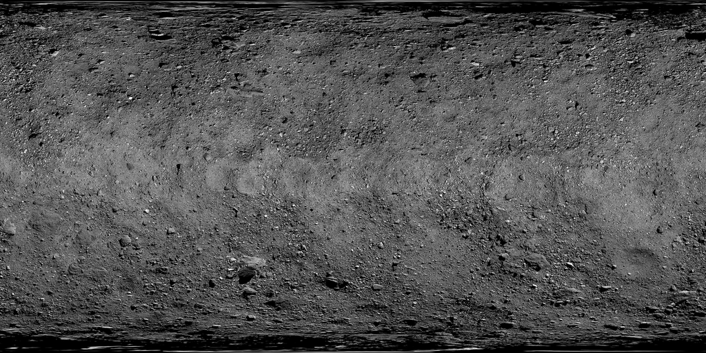
Global map of asteroid Bennu’s surface.
Summary
edit
| Description |
English: The global map of asteroid Bennu’s surface is a mosaic of images collected by NASA’s OSIRIS-REx spacecraft between Mar. 7 and Apr. 19, 2019. A total of 2,155 PolyCam images were stitched together and corrected to produce the mosaic. At 2 inches (5 cm) per pixel, this is the highest resolution at which a planetary body has been globally mapped. The spacecraft collected these images at distances ranging from 1.9 to 3.1 miles (3.1 to 5 km) above the asteroid’s surface. This detailed view of Bennu was used by the mission team during their selection of the primary and backup sample collection sites – Nightingale and Osprey.
Instrument Used: OCAMS (PolyCam) Rectangular projection (90°S-90°N/0°-360°E) |
| Date | |
| Source | https://www.asteroidmission.org/bennu_global_mosaic/ |
| Author | NASA/Goddard/University of Arizona |
| Other versions |
 |
Licensing
edit
| This file is in the public domain in the United States because it was solely created by NASA. NASA copyright policy states that "NASA material is not protected by copyright unless noted". (See Template:PD-USGov, NASA copyright policy page or JPL Image Use Policy.) | ||
 |
Warnings:
|
File history
Click on a date/time to view the file as it appeared at that time.
| Date/Time | Thumbnail | Dimensions | User | Comment | |
|---|---|---|---|---|---|
| current | 19:00, 6 May 2020 | | 2,400 × 1,200 (4.82 MB) | Yarnalgo (talk | contribs) | higher resolution |
| 17:01, 3 April 2020 |  | 1,041 × 521 (466 KB) | Ysogo (talk | contribs) | Uploaded a work by Credit: NASA/Goddard/University of Arizona from https://www.nasa.gov/image-feature/goddard/2020/bennu-in-unprecedented-detail with UploadWizard |
You cannot overwrite this file.
File usage on Commons
The following 3 pages use this file:
File usage on other wikis
The following other wikis use this file:
- Usage on ar.wikipedia.org
- Usage on it.wikipedia.org
- Tlanuwa Regio
- Pouakai Saxum
- Aetos Saxum
- Amihan Saxum
- Gargoyle Saxum
- Benben Saxum
- Huginn Saxum
- Muninn Saxum
- Roc Saxum
- Simurgh Saxum
- Strix Saxum
- Ocypete Saxum
- Thorondor Saxum
- Odile Saxum
- Odette Saxum
- Kongamato Saxum
- Gullinkambi Saxum
- Gamayun Saxum
- Dodo Saxum
- Ciinkwia Saxum
- Celaeno Saxum
- Camulatz Saxum
- Boobrie Saxum
- Aellopus Saxum