File:Berlengas-pt.svg

Size of this PNG preview of this SVG file: 738 × 600 pixels. Other resolutions: 295 × 240 pixels | 591 × 480 pixels | 945 × 768 pixels | 1,260 × 1,024 pixels | 2,520 × 2,048 pixels | 1,500 × 1,219 pixels.
Original file (SVG file, nominally 1,500 × 1,219 pixels, file size: 193 KB)
Captions
Captions
Add a one-line explanation of what this file represents
Summary edit
| Description |
|
||
| Date | |||
| Source |
Own work, from several maps :
Other data :
|
||
| Author | Sémhur | ||
| Other versions |
| ||
| Attribution (required by the license) | © Sémhur / Wikimedia Commons / | ||
| SVG | W3C-validity not checked.
|
||
| Atelier graphique |


| Camera location | | View this and other nearby images on: OpenStreetMap |
|---|
Licensing edit
I, the copyright holder of this work, hereby publish it under the following licenses:
| Copyleft: This work of art is free; you can redistribute it and/or modify it according to terms of the Free Art License. You will find a specimen of this license on the Copyleft Attitude site as well as on other sites. |
This file is licensed under the Creative Commons Attribution-Share Alike 4.0 International, 3.0 Unported, 2.5 Generic, 2.0 Generic and 1.0 Generic license.
- You are free:
- to share – to copy, distribute and transmit the work
- to remix – to adapt the work
- Under the following conditions:
- attribution – You must give appropriate credit, provide a link to the license, and indicate if changes were made. You may do so in any reasonable manner, but not in any way that suggests the licensor endorses you or your use.
- share alike – If you remix, transform, or build upon the material, you must distribute your contributions under the same or compatible license as the original.
You may select the license of your choice.
File history
Click on a date/time to view the file as it appeared at that time.
| Date/Time | Thumbnail | Dimensions | User | Comment | |
|---|---|---|---|---|---|
| current | 18:11, 10 January 2008 | | 1,500 × 1,219 (193 KB) | Sémhur (talk | contribs) | Ortographe |
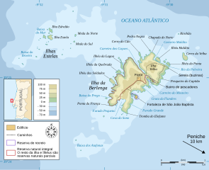
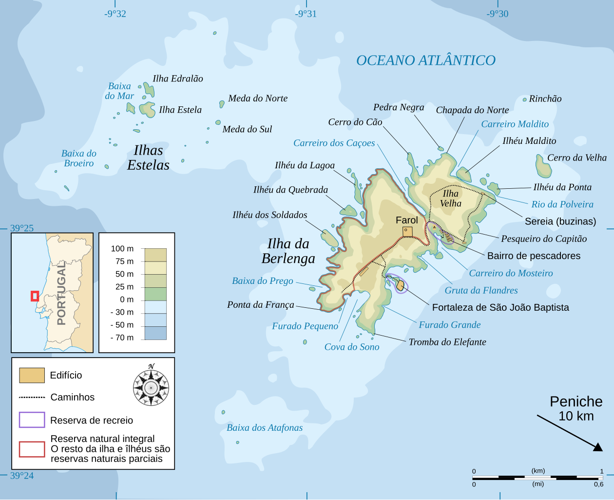
| 12:06, 4 January 2008 |  | 1,500 × 1,219 (193 KB) | Sémhur (talk | contribs) | {{Information |Description= {{en|Portuguese map of Berlenga Island and Estelas Islands.}} {{fr|Carte en portugais de l'île de Berlenga et des ilôts Estelas.}} {{pt|Mapa em português da ilha Berlenga e os ilhas Estelas.}} |Source=Own work, from several |
You cannot overwrite this file.
File usage on Commons
The following 3 pages use this file:
File usage on other wikis
The following other wikis use this file:
- Usage on de.wikipedia.org
- Usage on es.wikipedia.org
- Usage on fr.wikipedia.org
- Usage on pl.wikipedia.org
- Usage on pt.wikipedia.org