File:Berlin-Blankenfelde 1920.jpg

Size of this preview: 632 × 599 pixels. Other resolutions: 253 × 240 pixels | 506 × 480 pixels | 810 × 768 pixels | 1,157 × 1,097 pixels.
Original file (1,157 × 1,097 pixels, file size: 623 KB, MIME type: image/jpeg)
Captions
Captions
Add a one-line explanation of what this file represents
Summary edit
| Description |
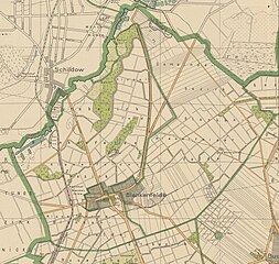
Deutsch: Karte der Gemeinde und des Gutsbezirks Blankenfelde mit den Grenzen von 1920 vor der Eingemeindung nach Groß-Berlin |
| Date | |
| Source |
https://digital.zlb.de/viewer/resolver?urn=urn:nbn:de:kobv:109-1-15465734 Übersichtsplan des Verwaltungsbezirks Pankow. Stadt Berlin. Bezirksvermessungsamt, 1921. |
| Author | Berlin-Pankow. Vermessungsamt |
Licensing edit
This work is in the public domain in the United States because it was published (or registered with the U.S. Copyright Office) before January 1, 1929.
Public domain works must be out of copyright in both the United States and in the source country of the work in order to be hosted on the Commons. If the work is not a U.S. work, the file must have an additional copyright tag indicating the copyright status in the source country.
Note: This tag should not be used for sound recordings. |
File history
Click on a date/time to view the file as it appeared at that time.
| Date/Time | Thumbnail | Dimensions | User | Comment | |
|---|---|---|---|---|---|
| current | 09:23, 15 February 2024 | | 1,157 × 1,097 (623 KB) | Definitiv (talk | contribs) | Uploaded a work by Berlin-Pankow. Vermessungsamt from https://digital.zlb.de/viewer/resolver?urn=urn:nbn:de:kobv:109-1-15465734 Übersichtsplan des Verwaltungsbezirks Pankow. Stadt Berlin. Bezirksvermessungsamt, 1921. with UploadWizard |
You cannot overwrite this file.
File usage on Commons
There are no pages that use this file.
File usage on other wikis
The following other wikis use this file:
- Usage on de.wikipedia.org