File:Berlin Lageplan High-Deck-Siedlung.png

Size of this preview: 517 × 600 pixels. Other resolutions: 207 × 240 pixels | 414 × 480 pixels | 662 × 768 pixels | 883 × 1,024 pixels | 1,677 × 1,945 pixels.
Original file (1,677 × 1,945 pixels, file size: 505 KB, MIME type: image/png)
Captions
Captions
Add a one-line explanation of what this file represents
Summary
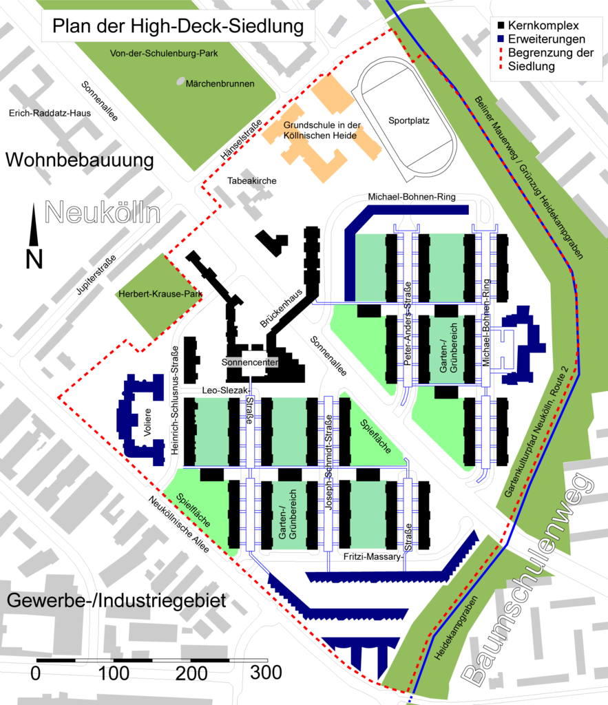
edit| Description |
Deutsch: Berlin: Lage- und Übersichtsplan der High-Deck-Siedlung |
||
| Date | 12.3.2011 | ||
| Source | = own work based on Openstreetmap data enriched with further details | ||
| Author | ONAR | ||
| Permission (Reusing this file) |
All OpenStreetMap data and maps are Creative Commons "CC-BY-SA 2.0" licensed | ||
| Other versions |
|

Licensing
edit
I, the copyright holder of this work, hereby publish it under the following license:
This file is licensed under the Creative Commons Attribution-Share Alike 3.0 Unported license.
- You are free:
- to share – to copy, distribute and transmit the work
- to remix – to adapt the work
- Under the following conditions:
- attribution – You must give appropriate credit, provide a link to the license, and indicate if changes were made. You may do so in any reasonable manner, but not in any way that suggests the licensor endorses you or your use.
- share alike – If you remix, transform, or build upon the material, you must distribute your contributions under the same or compatible license as the original.
File history
Click on a date/time to view the file as it appeared at that time.
| Date/Time | Thumbnail | Dimensions | User | Comment | |
|---|---|---|---|---|---|
| current | 17:45, 13 March 2011 | | 1,677 × 1,945 (505 KB) | ONAR (talk | contribs) | {{Information |Description= {{de|Berlin: Lage- und Übersichtsplan der High-Deck-Siedlung}} |Source= = own work based on [http://www.openstreetmap.org Openstreetmap] data enriched with further details |Date= 12.3.2011 |Author= ONAR |Permissi |
You cannot overwrite this file.
File usage on Commons
The following page uses this file:
File usage on other wikis
The following other wikis use this file:
- Usage on de.wikipedia.org
- Usage on www.wikidata.org