File:Bernese Alps ESA358217.tiff

Original file (6,000 × 6,000 pixels, file size: 123.05 MB, MIME type: image/tiff)
Captions
Captions
Summary edit
| Description |
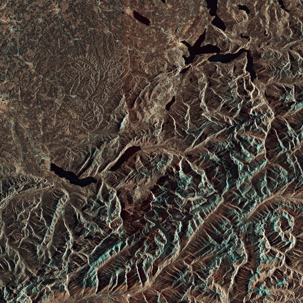
English: Part of the Swiss Alps are pictured in this Sentinel-1A image from 11 September 2015.
Near the centre of the image are lakes Thun and Brienz, with the city of Interlaken between them. In the upper-right section is Lake Lucerne. In the lower-central part of the image we can see the Aletsch Glacier, the largest in the Alps. The glacier originates in a large, flat area of snow and ice high in the mountains called Concordia, where three smaller glaciers converge. Switzerland’s three famous Eiger, Mönch and Jungfrau mountains rise north of Concordia. The Aletsch Glacier extends south, and its meltwater creates the Massa River in the valley below. Glaciers in this region are showing long-term retreat from climate change. The melting ice has given birth to new lakes, which pose risks such as flooding and landslides to communities below. Radar imagery can be used to generate precise elevation models, and can also detect deformation over landslide, seismic or subsidence areas. Radar can also support impact assessment for many types of hazard such as geological events. Sentinel-1’s radar ability to ‘see’ through clouds, rain and in darkness makes it particularly useful for monitoring floods. Images acquired before and after a flood offer immediate information on the extent of inundation and support assessments of property and environmental damage. Sentinel-1 is a two-satellite mission. Sentinel-1A was launched in April 2014 while its sister, Sentinel-1B, is set for launch on 22 April of this year. This image is also featured on theEarth from Space video programme. |
| Date | |
| Source | http://www.esa.int/spaceinimages/Images/2016/04/Bernese_Alps |
| Author | European Space Agency |
| Permission (Reusing this file) |
Contains modified Copernicus Sentinel data [2015], processed by ESA,CC BY-SA 3.0 IGO |
| Other versions |
|
| Title | Bernese Alps |
| Set | Earth observation image of the week |
| System | Copernicus |
| Mission | Sentinel-1 |
| Location | Switzerland |
| Activity | Observing the Earth |
| Keywords | Lakes; Lakes and rivers; Glaciers; Radar; Radar Images; Satellite image; Environment; Environment health; Mountain |

Licensing edit
- You are free:
- to share – to copy, distribute and transmit the work
- to remix – to adapt the work
- Under the following conditions:
- attribution – You must give appropriate credit, provide a link to the license, and indicate if changes were made. You may do so in any reasonable manner, but not in any way that suggests the licensor endorses you or your use.
- share alike – If you remix, transform, or build upon the material, you must distribute your contributions under the same or compatible license as the original.

|
This image contains data from a satellite in the Copernicus Programme, such as Sentinel-1, Sentinel-2 or Sentinel-3. Attribution is required when using this image.
Attribution: Contains modified Copernicus Sentinel data {{{year}}}
The use of Copernicus Sentinel Data is regulated under EU law (Commission Delegated Regulation (EU) No 1159/2013 and Regulation (EU) No 377/2014). Relevant excerpts:
Free access shall be given to GMES dedicated data [...] made available through GMES dissemination platforms [...].
Access to GMES dedicated data [...] shall be given for the purpose of the following use in so far as it is lawful:
GMES dedicated data [...] may be used worldwide without limitations in time.
GMES dedicated data and GMES service information are provided to users without any express or implied warranty, including as regards quality and suitability for any purpose. |
File history
Click on a date/time to view the file as it appeared at that time.
| Date/Time | Thumbnail | Dimensions | User | Comment | |
|---|---|---|---|---|---|
| current | 15:32, 7 May 2017 |  | 6,000 × 6,000 (123.05 MB) | Fæ (talk | contribs) | == {{int:filedesc}} == {{information | description = {{en|1=Part of the Swiss Alps are pictured in this Sentinel-1A image from 11 September 2015. Near the centre of the image are lakes Thun and Brienz, with the city of Interlaken between them. In the u... |
You cannot overwrite this file.
File usage on Commons
The following 2 pages use this file: