File:Biała (Bielsko-Biała) mapa 1908.jpg

Size of this preview: 358 × 598 pixels. Other resolutions: 143 × 240 pixels | 287 × 480 pixels | 459 × 768 pixels | 612 × 1,024 pixels | 1,225 × 2,048 pixels | 3,337 × 5,578 pixels.
Original file (3,337 × 5,578 pixels, file size: 2.28 MB, MIME type: image/jpeg)
Captions
Captions
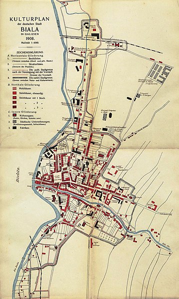
Map of the town of Biała in Galicia (today a district of Bielsko-Biała) from 1908 with the administrative and "natural" urban boundaries marked separately
Summary edit
_mapa_1908.jpg&action=edit§ion=1)
| Description |
Čeština: Mapa města Bělá v Haliči (dnes městská část Bílska-Bělé) z roku 1908 s vyznačením zvlášť administrativní a zvlášť přirozené urbanistické hranice
English: Map of the town of Biała in Galicia (today a district of Bielsko-Biała) from 1908 with the administrative and "natural" urban boundaries marked separately
Deutsch: Karte der Stadt Biala in Galizien (heute ein Stadtteil von Bielitz-Biala) aus dem Jahr 1908 mit getrennt markierten administrativen und „natürlichen” Stadtgrenzen
Polski: Mapa miasta Biała w Galicji (dziś część Bielska-Białej) z roku 1908 z zaznaczoną osobną granicą administracyjną i naturalną granicą urbanistyczną |
| Date | |
| Source | Biala, eine deutsche Stadt in Galizien: geographische Untersuchung des Stadtproblems |
| Author | Erwin Hanslik |
Licensing edit
_mapa_1908.jpg&action=edit§ion=2)
|
This work is in the public domain in its country of origin and other countries and areas where the copyright term is the author's life plus 70 years or fewer. This work is in the public domain in the United States because it was published (or registered with the U.S. Copyright Office) before January 1, 1929. | |
| This file has been identified as being free of known restrictions under copyright law, including all related and neighboring rights. | |
File history
Click on a date/time to view the file as it appeared at that time.
| Date/Time | Thumbnail | Dimensions | User | Comment | |
|---|---|---|---|---|---|
| current | 15:08, 2 August 2022 | | 3,337 × 5,578 (2.28 MB) | Gaj777 (talk | contribs) | Uploaded a work by Erwin Hanslik from Biala, eine deutsche Stadt in Galizien: geographische Untersuchung des Stadtproblems with UploadWizard |
You cannot overwrite this file.
File usage on Commons
There are no pages that use this file.
File usage on other wikis
The following other wikis use this file:
- Usage on pl.wikipedia.org
_mapa_1908.jpg&oldid=865058981)