File:Birmingham - Reform Act Map 1831.png
Size of this preview: 766 × 600 pixels. Other resolutions: 307 × 240 pixels | 613 × 480 pixels | 981 × 768 pixels | 1,280 × 1,002 pixels | 2,560 × 2,005 pixels | 2,947 × 2,308 pixels.
Original file (2,947 × 2,308 pixels, file size: 4.82 MB, MIME type: image/png)
Captions
Captions
Add a one-line explanation of what this file represents
Summary
edit
| Description |
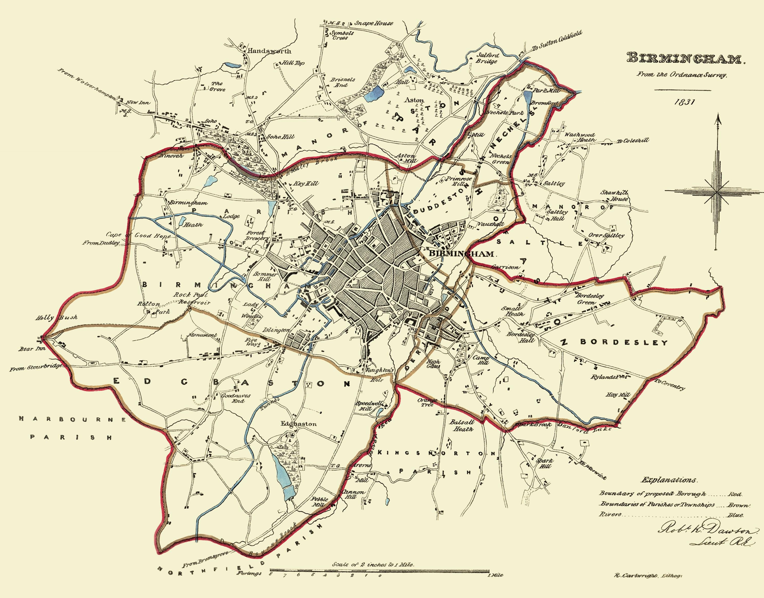
English: Map of the proposed Parliamentary Borough of Birmingham, surveyed in 1831 for the Great Reform Act by Robert K. Dawson. Source |
||||||||||||||||
| Date | |||||||||||||||||
| Source | http://www.mapseeker.co.uk/major-british-cities/birmingham/?id=41 | ||||||||||||||||
| Creator |
|
||||||||||||||||
| Geotemporal data | |||||||||||||||||
| Bounding box |
|
||||||||||||||||
| Georeferencing | |||||||||||||||||
Licensing
edit
|
This work is in the public domain in its country of origin and other countries and areas where the copyright term is the author's life plus 100 years or fewer. | |
| This file has been identified as being free of known restrictions under copyright law, including all related and neighboring rights. | |
Original upload log
edit
The original description page was here. All following user names refer to en.wikipedia.
| Date/Time | Dimensions | User | Comment |
|---|---|---|---|
| 2009-05-03 07:40 | 2947×2308× (5058654 bytes) | JimmyGuano | Map of the proposed [[Parliamentary Borough]] of [[Birmingham]], surveyed in 1831 for the [[Great Reform Act]] by [[Robert K. Dawson]]. |
File history
Click on a date/time to view the file as it appeared at that time.
| Date/Time | Thumbnail | Dimensions | User | Comment | |
|---|---|---|---|---|---|
| current | 06:02, 21 March 2016 | | 2,947 × 2,308 (4.82 MB) | FastilyClone (talk | contribs) | Transferred from enwp |
You cannot overwrite this file.
File usage on Commons
There are no pages that use this file.
File usage on other wikis
The following other wikis use this file:
- Usage on en.wikipedia.org
- Usage on www.wikidata.org