File:Birparjoy Floods India (MODIS).jpg
Original file (1,637 × 1,337 pixels, file size: 338 KB, MIME type: image/jpeg)
Captions
Captions
Summary
edit.jpg&action=edit§ion=1)
| Description |
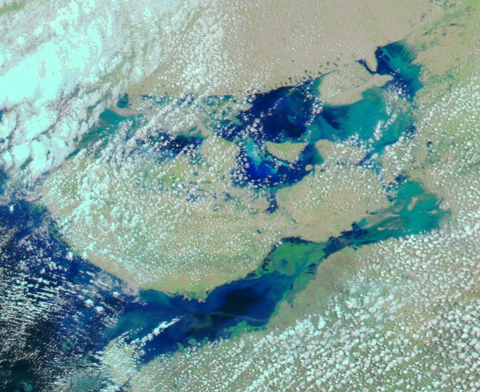
English: June 21, 2023 June 4, 2023
When Very Severe Cyclonic Storm Biparjoy made landfall on the coast of the state of Gujarat, India on June 15, 2023, it carried maximum sustained winds of about 64 mph (103 km/h) and torrential rain. The rain and storm surge sparked flooding and severe inundation of low-lying areas along the coast. Biparjoy moved slowly inland after landfall. Although it steadily weakened, the storm maintained tropical cyclone status as it continued to spin over Gujarat through June 16. By the next day, the storm weakened to a remnant low as it continued a slow crawl inland, relentlessly dumping heavy rain the entire time. While skies cleared over Gujarat by June 19, the storm remained a persistent rainmaker. According to The Weather Channel, the cyclone's remnant was sitting over Uttar Pradesh, a state in Northern India on June 21, where it continued to produce rain, including thunderstorms and lightening. Rain triggered by Biparjoy is expected to continue in Northern India until June 25. The Moderate Resolution Imaging Spectroradiometer (MODIS) on NASA’s Aqua satellite acquired a false-color image of coastal Gujarat state on June 21, 2023, that shows heavy inundation especially inland over the Great Rann of Kutch and the Little Rann of Kutch. A second MODIS Aqua false-color image of the same region acquired on June 4 can be revealed by clicking on the date below the image. This type of false-color image helps distinguish water from land. Water typically appears deep blue, although suspended sediment may look lighter blue or green. Heavily vegetated land looks bright green, while open land takes on brown or tan hues. Clouds may appear white or be tinted with a light electric blue. The Kutch district of Gujarat state contains one of the largest salt deserts in the world: the Rann of Kutch, (Rann means desert in Hindi) which is divided into the Great Rann (north) and the Little Rann (south). Thousands of years ago the Rann was a shallow arm of the Arabian Sea, but today is an extensive saline mudflat. During the dry season, which ends by July, it is extremely dry, as can be seen in the June 4 image. Each year, the area is slowly renewed as a shallow wetland after the monsoon rains begin to fall. However, rains from Cyclone Biparjoy brought extreme floods by June 21, inundating not only the Rann of Kutch but much of Gujarat state. |
||
| Date | Taken on 21 June 2023 | ||
| Source |
Birparjoy Floods India (direct link)
|
||
| Author | MODIS Land Rapid Response Team, NASA GSFC |
| This media is a product of the Aqua mission Credit and attribution belongs to the mission team, if not already specified in the "author" row |
Licensing
edit.jpg&action=edit§ion=2)
| This file is in the public domain in the United States because it was solely created by NASA. NASA copyright policy states that "NASA material is not protected by copyright unless noted". (See Template:PD-USGov, NASA copyright policy page or JPL Image Use Policy.) | ||
 |
Warnings:
|
File history
Click on a date/time to view the file as it appeared at that time.
| Date/Time | Thumbnail | Dimensions | User | Comment | |
|---|---|---|---|---|---|
| current | 18:54, 31 July 2023 | | 1,637 × 1,337 (338 KB) | OptimusPrimeBot (talk | contribs) | #Spacemedia - Upload of http://modis.gsfc.nasa.gov/gallery/images/image06222023_250m.jpg via Commons:Spacemedia |
You cannot overwrite this file.
File usage on Commons
There are no pages that use this file.
.jpg&oldid=863853673)