File:Black Rock Station - geograph.org.uk - 1117433.jpg
No higher resolution available.
Black_Rock_Station_-_geograph.org.uk_-_1117433.jpg (640 × 480 pixels, file size: 92 KB, MIME type: image/jpeg)
Captions
Captions
Add a one-line explanation of what this file represents
Summary
edit
| Description |
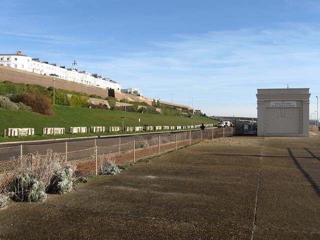
English: Black Rock Station This is the fourth station to have operated as the Black Rock eastern terminus of Volks Railway. The original terminus was at Banjo Groyne opposite Paston Place where the current halfway station is. The line was extended in 1901 to a point much further east which remained until 1937 when the new Black Rock open air swimming pool was built on the site requiring the station to move a couple of hundred yards to the west. This building was replaced in 1948 and remained in place until the early 1990s when a storm drainage scheme required the demolition of that building and another 100 yards moved to the west to be replaced by the current one in view.
To the left of the railway is Madeira Drive the seafront road that leaves the A259 next to Palace Pier and has gradually extended itself eastwards through the years, initially rejoining Marine Parade at Dukes Mound in 1872 it was extended to Black Rock in 1895 and rejoined Marine Parade to the east of Arundel Terrace, in view above Kemp Town slopes, until that was blocked when the new access roads for Brighton Marina were begun in the early 1970s turning this part into a dead end particularly once the swimming pool closed in 1978, its current uses seems to be for parking coaches in the summer, as a quiet place for learner drivers to practice three point turns, for men to pick up other men, and as a frequent stopping point for a number of Irish travellers, a fair few of whom were back there on this day. That is part of the reason why the concrete blocks are in place over the far side of the road to prevent vehicular access. |
| Date | |
| Source | From geograph.org.uk |
| Author | Simon Carey |
| Attribution (required by the license) | Simon Carey / Black Rock Station / |
| Camera location | | View this and other nearby images on: OpenStreetMap |
|---|
_heading:90.00&language=en)
| Object location | | View this and other nearby images on: OpenStreetMap |
|---|
_heading:90.00&language=en)
Licensing
edit

|
This image was taken from the Geograph project collection. See this photograph's page on the Geograph website for the photographer's contact details. The copyright on this image is owned by Simon Carey and is licensed for reuse under the Creative Commons Attribution-ShareAlike 2.0 license.
|
This file is licensed under the Creative Commons Attribution-Share Alike 2.0 Generic license.
Attribution: Simon Carey
- You are free:
- to share – to copy, distribute and transmit the work
- to remix – to adapt the work
- Under the following conditions:
- attribution – You must give appropriate credit, provide a link to the license, and indicate if changes were made. You may do so in any reasonable manner, but not in any way that suggests the licensor endorses you or your use.
- share alike – If you remix, transform, or build upon the material, you must distribute your contributions under the same or compatible license as the original.
File history
Click on a date/time to view the file as it appeared at that time.
| Date/Time | Thumbnail | Dimensions | User | Comment | |
|---|---|---|---|---|---|
| current | 20:33, 24 February 2011 | | 640 × 480 (92 KB) | GeographBot (talk | contribs) | == {{int:filedesc}} == {{Information |description={{en|1=Black Rock Station This is the fourth station to have operated as the Black Rock eastern terminus of Volks Railway. The original terminus was at Banjo Groyne opposite Paston Place where the current |
You cannot overwrite this file.
File usage on Commons
There are no pages that use this file.