File:Blair's Landing Battlefield Louisiana.jpg

Size of this preview: 778 × 599 pixels. Other resolutions: 312 × 240 pixels | 623 × 480 pixels | 997 × 768 pixels | 1,280 × 986 pixels | 1,350 × 1,040 pixels.
Original file (1,350 × 1,040 pixels, file size: 437 KB, MIME type: image/jpeg)
Captions
Captions
Add a one-line explanation of what this file represents
Summary edit
| Description |
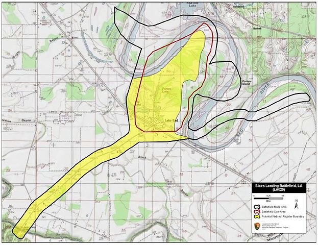
English: Map of battlefield core and study areas.
The ABPP adjusted the Study Area to conform to the course of the Red River c. 1864. Also, the ABPP added the approach route used by BG Thomas Green’s Cavalry Division. Green was attempting to intercept the Federal flotilla, which was slowly working its way down the Red River. The Core Area reflects the nearly two-mile front covered by the Federal gunboats and army transports as they moved down the river. |
| Date | |
| Source | National Park Service |
| Author | American Battlefield Protection Program |
Licensing edit
This work is in the public domain in the United States because it is a work prepared by an officer or employee of the United States Government as part of that person’s official duties under the terms of Title 17, Chapter 1, Section 105 of the US Code.
Note: This only applies to original works of the Federal Government and not to the work of any individual U.S. state, territory, commonwealth, county, municipality, or any other subdivision. This template also does not apply to postage stamp designs published by the United States Postal Service since 1978. (See § 313.6(C)(1) of Compendium of U.S. Copyright Office Practices). It also does not apply to certain US coins; see The US Mint Terms of Use.
|
 | |
| This file has been identified as being free of known restrictions under copyright law, including all related and neighboring rights. | ||
File history
Click on a date/time to view the file as it appeared at that time.
| Date/Time | Thumbnail | Dimensions | User | Comment | |
|---|---|---|---|---|---|
| current | 21:08, 21 December 2016 | | 1,350 × 1,040 (437 KB) | SDriskell (talk | contribs) | User created page with UploadWizard |
You cannot overwrite this file.
File usage on Commons
The following page uses this file:
File usage on other wikis
The following other wikis use this file:
- Usage on en.wikipedia.org
- Usage on fr.wikipedia.org