File:Blowhole Cave - geograph.org.uk - 1461149.jpg
No higher resolution available.
Blowhole_Cave_-_geograph.org.uk_-_1461149.jpg (640 × 427 pixels, file size: 261 KB, MIME type: image/jpeg)
Captions
Captions
Add a one-line explanation of what this file represents
Summary
edit
| Description |
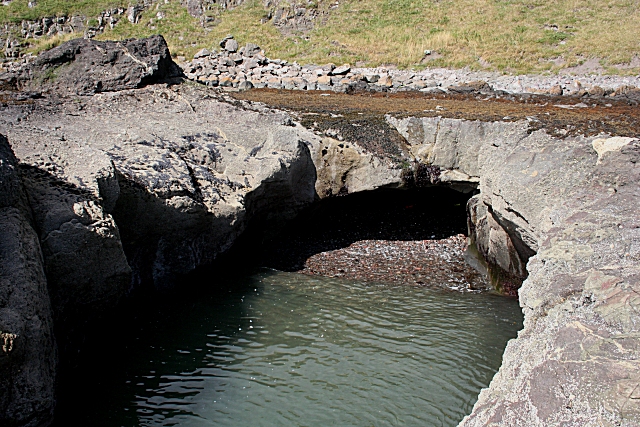
English: Blowhole Cave This cave, visible only at a very low tide, extends right under the flat wave-cut platform. When it isn't clogged with stones and gravel, and there's a big swell coming straight into the cave from the south-east, and the level of the tide is right, the water pressure produces intermittent fountaining through crevices in the rock at the far side of the platform. The only way to set foot in the cave is to land with a kayak. |
| Date | |
| Source | From geograph.org.uk |
| Author | Anne Burgess |
| Attribution (required by the license) | Anne Burgess / Blowhole Cave / |
| Camera location | | View this and other nearby images on: OpenStreetMap |
|---|
_heading:315.00&language=en)
| Object location | | View this and other nearby images on: OpenStreetMap |
|---|
_heading:315.00&language=en)
Licensing
edit

|
This image was taken from the Geograph project collection. See this photograph's page on the Geograph website for the photographer's contact details. The copyright on this image is owned by Anne Burgess and is licensed for reuse under the Creative Commons Attribution-ShareAlike 2.0 license.
|
This file is licensed under the Creative Commons Attribution-Share Alike 2.0 Generic license.
Attribution: Anne Burgess
- You are free:
- to share – to copy, distribute and transmit the work
- to remix – to adapt the work
- Under the following conditions:
- attribution – You must give appropriate credit, provide a link to the license, and indicate if changes were made. You may do so in any reasonable manner, but not in any way that suggests the licensor endorses you or your use.
- share alike – If you remix, transform, or build upon the material, you must distribute your contributions under the same or compatible license as the original.
File history
Click on a date/time to view the file as it appeared at that time.
| Date/Time | Thumbnail | Dimensions | User | Comment | |
|---|---|---|---|---|---|
| current | 07:55, 2 March 2011 | | 640 × 427 (261 KB) | GeographBot (talk | contribs) | == {{int:filedesc}} == {{Information |description={{en|1=Blowhole Cave This cave, visible only at a very low tide, extends right under the flat wave-cut platform. When it isn't clogged with stones and gravel, and there's a big swell coming straight into t |
You cannot overwrite this file.
File usage on Commons
There are no pages that use this file.