File:Bluff with fault, Lospe fm(?) or older Quaternary gravels? (50778094776).jpg

Original file (4,008 × 3,006 pixels, file size: 14.06 MB, MIME type: image/jpeg)
Captions
Captions
Summary
edit_or_older_Quaternary_gravels%3F_(50778094776).jpg&action=edit§ion=1)
| Description |
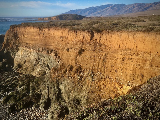
Bedrock under the gravels is the San Simeon ophiolite complex, a dike and sill complex which represents (I think) an old spreading center on the Jurassic(?) seafloor, as basaltic dikes were injected into the spreading "crack" to make new ocean floor. Sea-floor spreading was the key discovery in the then-new global tectonics which has evolved into the present-day understanding of plate tectonics, the details of which are way above my [retired] geologic pay-grade. Here, the diagnostic rock-type is microdiorite, which is simply finer-grained diorite: coarser than diabase, which is also reported to be present, but which I haven't yet seen. As you can see in the photo, the cobbles are sorted and crudely bedded, meaning they were deposited in fast-moving water. The yellow-brown color, from iron oxides, means deposition was subaerial = non-marine. I'm not sure what the story is for the larger, rounded "bowling-ball" cobbles below the bluff, except that they get rounded in the pounding surf, and are obviously strong! And not so easy to examine in person, for an old codger. Structure: at the center of the photo, you will see a break (fault) with the right (south) side down. The unnamed fault displaced both bedrock and the older gravels. It was unmapped in the 1970s-era USGS mapping. It is likely a minor splay off one of the many faults which are more-or-less parallel to the coast, all likely related to the currently-active San Andreas fault system further east. According to my geologic guidebook, SLO county is moving North at around 1.5 inches a year. Which will bring us adjacent to downtown San Francisco in about 5 million years.... 🙀 Better shopping but worse traffic! To the north is Point Sierra Nevada (rounded hill above it) and beyond that, the Santa Lucia mountains meeting the ocean about 15 miles north of here. |
| Date | |
| Source | Bluff with fault, Lospe fm(?) or older Quaternary gravels? |
| Author | Peter D. Tillman from USA |
| Camera location | | View this and other nearby images on: OpenStreetMap |
|---|
_or_older_Quaternary_gravels%3F_(50778094776).jpg¶ms=035.705188_N_-121.306673_E_globe:Earth_type:camera_source:Flickr_&language=en)
Licensing
edit_or_older_Quaternary_gravels%3F_(50778094776).jpg&action=edit§ion=2)
- You are free:
- to share – to copy, distribute and transmit the work
- to remix – to adapt the work
- Under the following conditions:
- attribution – You must give appropriate credit, provide a link to the license, and indicate if changes were made. You may do so in any reasonable manner, but not in any way that suggests the licensor endorses you or your use.
- share alike – If you remix, transform, or build upon the material, you must distribute your contributions under the same or compatible license as the original.
| This image was originally posted to Flickr by Pete Tillman at https://flickr.com/photos/29050464@N06/50778094776. It was reviewed on 26 July 2021 by FlickreviewR 2 and was confirmed to be licensed under the terms of the cc-by-sa-2.0. |
File history
Click on a date/time to view the file as it appeared at that time.
| Date/Time | Thumbnail | Dimensions | User | Comment | |
|---|---|---|---|---|---|
| current | 00:47, 26 July 2021 | | 4,008 × 3,006 (14.06 MB) | Orizan (talk | contribs) | Transferred from Flickr via #flickr2commons |
You cannot overwrite this file.
File usage on Commons
There are no pages that use this file.
_or_older_Quaternary_gravels%3F_(50778094776).jpg&oldid=879019577)