File:Boeing C-75 ICD primary wartime transatlantic routes.jpg

Size of this preview: 703 × 599 pixels. Other resolutions: 282 × 240 pixels | 563 × 480 pixels | 901 × 768 pixels | 1,201 × 1,024 pixels | 1,524 × 1,299 pixels.
Original file (1,524 × 1,299 pixels, file size: 759 KB, MIME type: image/jpeg)
Captions
Captions
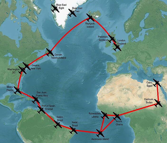
Boeing C-75 ICD primary wartime transatlantic routes
Summary
edit
| Description |
English: Boeing C-75 ICD primary wartime transatlantic routes based on map in Betts, Ed (February 1992). "The Intercontinental Division". TARPA Topics. Belhaven, NC: the Active Retired Pilot's Association of TWA. p.76. |
| Date | |
| Source | Own work |
| Author | NiD.29 |
Licensing
edit
I, the copyright holder of this work, hereby publish it under the following license:
This file is licensed under the Creative Commons Attribution-Share Alike 4.0 International license.
- You are free:
- to share – to copy, distribute and transmit the work
- to remix – to adapt the work
- Under the following conditions:
- attribution – You must give appropriate credit, provide a link to the license, and indicate if changes were made. You may do so in any reasonable manner, but not in any way that suggests the licensor endorses you or your use.
- share alike – If you remix, transform, or build upon the material, you must distribute your contributions under the same or compatible license as the original.
File history
Click on a date/time to view the file as it appeared at that time.
| Date/Time | Thumbnail | Dimensions | User | Comment | |
|---|---|---|---|---|---|
| current | 18:39, 19 July 2022 | | 1,524 × 1,299 (759 KB) | NiD.29 (talk | contribs) | add London, couldn't see on original map |
| 14:47, 19 July 2022 |  | 1,506 × 1,293 (734 KB) | NiD.29 (talk | contribs) | add missing location and redo on different projection because the map needed wasn't available in the desired projection | |
| 12:33, 19 July 2022 |  | 950 × 818 (248 KB) | NiD.29 (talk | contribs) | Uploaded own work with UploadWizard |
You cannot overwrite this file.
File usage on Commons
The following page uses this file:
- File:ICD transatlantic routes.png (file redirect)
File usage on other wikis
The following other wikis use this file:
- Usage on en.wikipedia.org