File:Bohus1645.jpg

Original file (3,317 × 2,527 pixels, file size: 1.77 MB, MIME type: image/jpeg)
Captions
Captions
Summary edit
| Description |
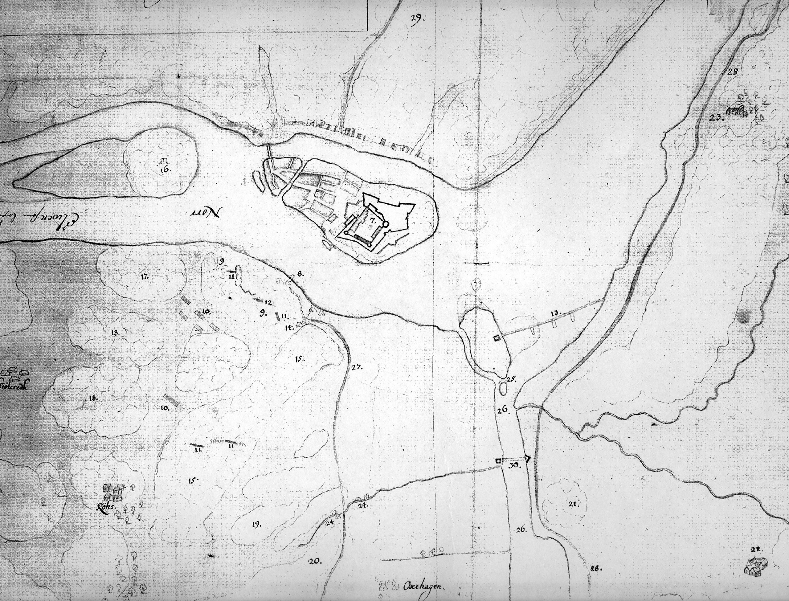
English: Detail from swedish map of the surroundings of Bohus fortress during a siege in August 1645.
7) The danish-norwegian fortress Bohus, and town Ny-Kungälv. 9) Places were minor fighting have occurred. 10) Swedish cavallery 11) and 12) Swedish gunbatteries 13) Danish-norwegian obstacle in the river Göta älv, with defense redoubt. 16) Gallows hill 22) Farm in Skårdals skate, in danish-norwegian territory. 23) Farm in swedish territory 24) Watermills 25) Smygen, man made channel for small vessels. 27) Road to Gothenburg 28) Road between Gothenburg and Vänersborg 29) The mountain Fontin 30) Movable bridge, also made permanent in the war 1657.Svenska: Detalj från svensk situationskarta vid general Lars Kaggs belägring av Bohus fästning i augusti 1645.
7) Bohus fästning och staden Ny-Kungälv. 8) Färjestaden 9) Platser där skärmytsling (mindre strider) ägt rum med fientligt fotfolk. 10) Svenskt kavalleri 11) och 12) Svenska batterier med belägringsartilleri 13) Dansk-norskt sänkverk med försvars-redutt på Fiskarholmen. 14) Vedbacka 15) Långåsen 16) Tjuvholmen eller Galgberget 17) Gamla galgberget 18) Lövåsen 20) Kvarnåsen 21) Gräsåsen 22) En av gårdarna i Skårdals by i det dansk-norska området Skårdals skate. 23) Gården Nedre Viken (Lilla Viken) på svenskt område. 24) vattenkvarnar 25) Smygen, grävd kanal för mindre fartyg innanför Fiskarholmen. 26) Jordfallet 27) Landvsäg mellan Bohus och Göteborgs hospital, strax norr om Säveån. 28) Landsväg mellan Göteborg och Vänersborg. 29) Berget Fontin 30) Fiendens flytbrygga, även använd permanent under Krabbefejden 1657. |
| Date | |
| Source | Krigsarkivet, Stockholm ; Sveriges Krig 4:172 |
| Author | Anonymous |
| Other versions | Derivative works of this file: Bohus1645 cropped.jpg |
Licensing edit
|
This work is in the public domain in its country of origin and other countries and areas where the copyright term is the author's life plus 70 years or fewer.
| |
| This file has been identified as being free of known restrictions under copyright law, including all related and neighboring rights. | |
File history
Click on a date/time to view the file as it appeared at that time.
| Date/Time | Thumbnail | Dimensions | User | Comment | |
|---|---|---|---|---|---|
| current | 20:10, 23 February 2011 | | 3,317 × 2,527 (1.77 MB) | Dagjoh (talk | contribs) | {{Information |Description ={{en|1=Detail from swedish map of the surroundings of Bohus fortress during a siege in August 1645. 7) The danish-norwegian fortress Bohus, and town Ny-Kungälv. 9) Places were minor fighting have occurred. 10) Swedish cava |
You cannot overwrite this file.
File usage on Commons
The following page uses this file:
File usage on other wikis
The following other wikis use this file:
- Usage on sv.wikipedia.org