File:Bonstetten Confederacy 1479.jpg

Size of this preview: 642 × 600 pixels. Other resolutions: 257 × 240 pixels | 514 × 480 pixels | 687 × 642 pixels.
Original file (687 × 642 pixels, file size: 166 KB, MIME type: image/jpeg)
Captions
Captions
Add a one-line explanation of what this file represents
Summary
edit
| Description |
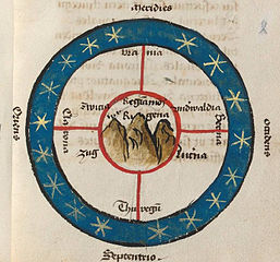
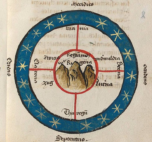
English: diagrammatic "map" of the Swiss Confederacy |
| Date | |
| Source | BNF Ms. Lat. 5656, reproduced in: Sieber-Lehmann, Claudius, 'Albrecht von Bonstettens geographische Darstellung der Schweiz von 1479', Cartographica Helvetica : Fachzeitschrift für Kartengeschichte 16 (1997) https://dx.doi.org/10.5169/seals-9073 |
| Author | Albrecht von Bonstetten |
Licensing
edit
|
This work is in the public domain in its country of origin and other countries and areas where the copyright term is the author's life plus 100 years or fewer. This work is in the public domain in the United States because it was published (or registered with the U.S. Copyright Office) before January 1, 1929. | |
| This file has been identified as being free of known restrictions under copyright law, including all related and neighboring rights. | |
File history
Click on a date/time to view the file as it appeared at that time.
| Date/Time | Thumbnail | Dimensions | User | Comment | |
|---|---|---|---|---|---|
| current | 17:15, 23 January 2016 | | 687 × 642 (166 KB) | Dbachmann (talk | contribs) | {{Information |Description ={{en|1=diagrammatic "map" of the Swiss Confederacy}} |Source =15th-century manuscript, immediate source [http://www.presseportal.ch/de/pm/100002863/100587435 presseportal.ch] |Author =Albrecht von Bonstett... |
You cannot overwrite this file.
File usage on Commons
There are no pages that use this file.
File usage on other wikis
The following other wikis use this file:
- Usage on arz.wikipedia.org
- Usage on en.wikipedia.org
- Usage on ja.wikipedia.org
- Usage on ru.wikipedia.org
- Usage on sl.wikipedia.org