File:Borderization South Ossetia at Saribari village.jpg

Size of this preview: 800 × 536 pixels. Other resolutions: 320 × 214 pixels | 640 × 428 pixels | 1,024 × 685 pixels | 1,280 × 857 pixels | 2,560 × 1,714 pixels | 3,872 × 2,592 pixels.
Original file (3,872 × 2,592 pixels, file size: 4.36 MB, MIME type: image/jpeg)
Captions
Captions
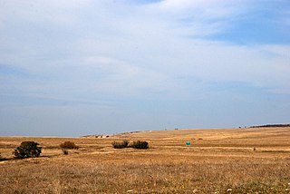
Borderization South Ossetia at Saribari village
Summary edit
| Description |
English: A "border" sign in the middle of the field, discouraging landowners to go to their land behind the sign. The ABL runs somewhere between the sign and the camera, meaning landowners risk being arrested for trespassing the ABL despite thinking they are not. This happens a lot. |
| Date | |
| Source | https://flickr.com/photos/34523388@N06/29669026464 |
| Author | Jelger Groeneveld |
| Camera location | | View this and other nearby images on: OpenStreetMap |
|---|
Licensing edit
I, the copyright holder of this work, hereby publish it under the following license:
This file is licensed under the Creative Commons Attribution 4.0 International license.
- You are free:
- to share – to copy, distribute and transmit the work
- to remix – to adapt the work
- Under the following conditions:
- attribution – You must give appropriate credit, provide a link to the license, and indicate if changes were made. You may do so in any reasonable manner, but not in any way that suggests the licensor endorses you or your use.
File history
Click on a date/time to view the file as it appeared at that time.
| Date/Time | Thumbnail | Dimensions | User | Comment | |
|---|---|---|---|---|---|
| current | 10:46, 12 July 2017 | | 3,872 × 2,592 (4.36 MB) | Labrang (talk | contribs) | User created page with UploadWizard |
You cannot overwrite this file.
File usage on Commons
There are no pages that use this file.
File usage on other wikis
The following other wikis use this file:
- Usage on nl.wikipedia.org