File:Brakrivier near Prieska, crop.jpg

Size of this preview: 800 × 468 pixels. Other resolutions: 320 × 187 pixels | 640 × 374 pixels | 1,024 × 599 pixels | 1,280 × 749 pixels | 1,763 × 1,031 pixels.
Original file (1,763 × 1,031 pixels, file size: 591 KB, MIME type: image/jpeg)
Captions
Captions
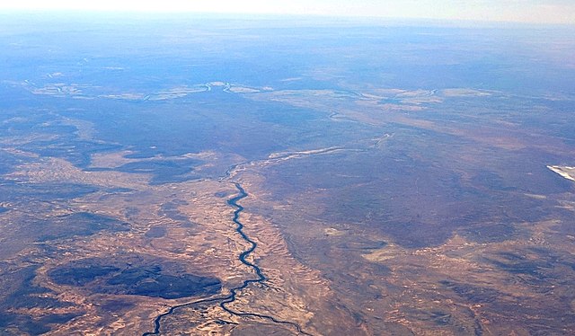
Aerial view of a section of the Northern Cape, South Africa
Summary
edit
| Description |
Afrikaans: 'n Noordwaartse gesig op die Bo-Karoo, Noord-Kaap, Suid-Afrika, afgeneem tydens 'n vlug tussen Dubai en Kaapstad. Die samevloeiing van die Ongersrivier (onder, links) en Brakrivier (onder, regs en stroomaf van die samevloeiing) is sigbaar aan die onderkant van die beeld. Die Brak het 'n samevloeiing met die Oranjerivier, wat op die agtergrond sigbaar is. 'n Doleriet-indringing, bekend as Biega se Berg (1 102 m), is net links van die Ongers-Brak-samevloeiing sigbaar. Die rivierbeddings van die Ongers- en Brakriviere is dig begroei met Acacia-bome wat oorleef danksy sporadiese vloede en ondergrondse beddingwater, wat hier die illusie van staande water gee.
English: Looking north over the Karoo, Northern Cape, South Africa, during a flight between Dubai and Cape Town. The confluence of the Ongers River (below, left) and Brak River (from below, right and beyond the confluence) is visible at the bottom of the picture. The Brak has a confluence with the Orange River, which is visible in the background. A dolerite intrusion, known as Biega se Berg (1,102 m), is visible to the immediate left of the Ongers-Brak confluence. The river beds of the Ongers and Brak rivers are densely vegetated with Acacia trees which benefit from occasional floods and subterranean water, giving the illusion of standing water. |
| Date | |
| Source | Own work |
| Author | Parrot of Doom |
| Other versions |
|
| Camera location | | View this and other nearby images on: OpenStreetMap |
|---|
| Object location | | View this and other nearby images on: OpenStreetMap |
|---|
Licensing
edit
I, the copyright holder of this work, hereby publish it under the following license:
This file is licensed under the Creative Commons Attribution-Share Alike 4.0 International license.
- You are free:
- to share – to copy, distribute and transmit the work
- to remix – to adapt the work
- Under the following conditions:
- attribution – You must give appropriate credit, provide a link to the license, and indicate if changes were made. You may do so in any reasonable manner, but not in any way that suggests the licensor endorses you or your use.
- share alike – If you remix, transform, or build upon the material, you must distribute your contributions under the same or compatible license as the original.
| Annotations | This image is annotated: View the annotations at Commons |
File history
Click on a date/time to view the file as it appeared at that time.
| Date/Time | Thumbnail | Dimensions | User | Comment | |
|---|---|---|---|---|---|
| current | 10:35, 11 February 2021 | | 1,763 × 1,031 (591 KB) | JMK (talk | contribs) | Uploaded own work with UploadWizard |
You cannot overwrite this file.
File usage on Commons
The following page uses this file:
File usage on other wikis
The following other wikis use this file:
- Usage on af.wikipedia.org
- Usage on ceb.wikipedia.org