File:Brazil-16-map.jpg
Brazil-16-map.jpg (379 × 516 pixels, file size: 277 KB, MIME type: image/jpeg)
Captions
Captions
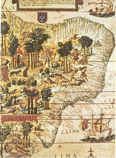
| Description | Map of Brazil in the Miller Atlas of 1519. Scan from 《社会历史博物馆》 ISBN 7-5347-1397-8 "社会历史博物馆" / "Social Historical Museum" 16世纪巴西的地图 / The map of Brasil in 16th century 1519年葡萄牙人绘制 / Issued in Portugal in 1519 |
| Date | Brazil 1500 |
| Source | scan from 《社会历史博物馆》 ISBN 7-5347-1397-8 |
| Author | 《社会历史博物馆》 |
| Other versions |
 |
|
This work is in the public domain in its country of origin and other countries and areas where the copyright term is the author's life plus 70 years or fewer.
| |
| This file has been identified as being free of known restrictions under copyright law, including all related and neighboring rights. | |
File history
Click on a date/time to view the file as it appeared at that time.
| Date/Time | Thumbnail | Dimensions | User | Comment | |
|---|---|---|---|---|---|
| current | 19:00, 6 June 2005 | | 379 × 516 (277 KB) | Shizhao (talk | contribs) | scan from 《社会历史博物馆》 ISBN 7-5347-1397-8 16世纪巴西的地图 1519年葡萄牙人绘制 {{PD}} |
You cannot overwrite this file.
File usage on Commons
The following 5 pages use this file:
File usage on other wikis
The following other wikis use this file:
- Usage on af.wikipedia.org
- Usage on ar.wikipedia.org
- Usage on azb.wikipedia.org
- Usage on ba.wikipedia.org
- Usage on bg.wikipedia.org
- Usage on ca.wikipedia.org
- Usage on cs.wikipedia.org
- Usage on da.wikipedia.org
- Usage on de.wikipedia.org
- Usage on el.wikipedia.org
- Usage on en.wikipedia.org
- Usage on en.wikibooks.org
- Usage on eo.wikipedia.org
- Usage on es.wikipedia.org
- Usage on fa.wikipedia.org
- Usage on fr.wikipedia.org
View more global usage of this file.