File:Brazilian States by Literacy rate.svg

Size of this PNG preview of this SVG file: 681 × 600 pixels. Other resolutions: 273 × 240 pixels | 545 × 480 pixels | 872 × 768 pixels | 1,163 × 1,024 pixels | 2,325 × 2,048 pixels | 780 × 687 pixels.
Original file (SVG file, nominally 780 × 687 pixels, file size: 401 KB)
Captions
Captions
Add a one-line explanation of what this file represents
| This image was created / taken by João Felipe C.S. |
| Description |
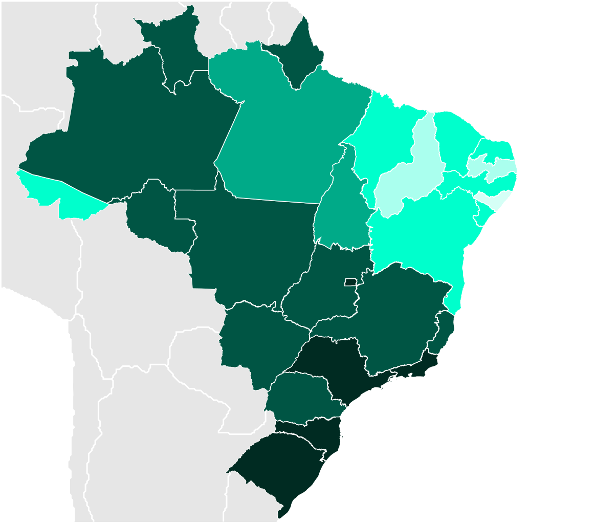
English: Map of Brazilian states by literacy rate (2010).
Português: Mapa dos estados brasileiros por índice de literacia (2010).
95-100%
90-94,9%
85-89,9%
80-84,9%
75-79,9%
This W3C-unspecified vector image was created with Inkscape . |
||||||||
| Date | |||||||||
| Source | Own work | ||||||||
| Author | Felipe Menegaz | ||||||||
| Permission (Reusing this file) |
I, Felipe Menegaz, the copyright holder of this work, hereby publishes it under the following licenses:
This file is licensed under the Creative Commons Attribution-Share Alike 2.5 Generic, 2.0 Generic and 1.0 Generic license. Attribution: I, Felipe Menegaz
You may select the license of your choice. |
||||||||
| Other versions |
|


File history
Click on a date/time to view the file as it appeared at that time.
| Date/Time | Thumbnail | Dimensions | User | Comment | |
|---|---|---|---|---|---|
| current | 01:53, 7 February 2017 | | 780 × 687 (401 KB) | Juniorpetjua (talk | contribs) | Atualização - 2010 |
| 21:00, 5 September 2011 |  | 780 × 687 (400 KB) | Chronus (talk | contribs) | Reverted to version as of 20:30, 23 August 2011 | |
| 22:11, 23 August 2011 |  | 780 × 687 (426 KB) | Juniorpetjua (talk | contribs) | Alteração das cores com base no mapa da ONU disponível na Wikimedia (File:World literacy map UNHD 2007 2008.png) | |
| 20:30, 23 August 2011 |  | 780 × 687 (400 KB) | Chronus (talk | contribs) | Reverted to version as of 21:58, 14 October 2009 | |
| 23:00, 22 August 2011 |  | 780 × 687 (426 KB) | Juniorpetjua (talk | contribs) | Alterando mapa com base nas cores usadas pela ONU para as taxas de analfabetismo. | |
| 21:58, 14 October 2009 |  | 780 × 687 (400 KB) | Muri1902 (talk | contribs) | Atualizando dados | |
| 17:11, 1 October 2008 |  | 780 × 687 (399 KB) | Giro720 (talk | contribs) | Updated version (2007 data) | |
| 02:06, 20 May 2008 |  | 780 × 687 (399 KB) | Giro720 (talk | contribs) | Atualizando dados | |
| 23:31, 11 June 2007 |  | 780 × 687 (639 KB) | Felipe Menegaz (talk | contribs) | {{User:João Felipe C.S/by}} {{Information |Description= {{en|Map of Brazilian states by literacy rate.}} {{pt|Mapa dos estados brasileiros por índice de literacia.}} ---- {{Inkscape}} |Source= Own work |Date= June 7, 2007 |Author= [[User:João Felipe C | |
| 03:43, 8 June 2007 |  | 780 × 687 (505 KB) | Felipe Menegaz (talk | contribs) | {{Information |Description= {{en|Map of Brazilian states by literacy rate.}} {{pt|Mapa dos estados brasileiros por índice de literacia.}} ---- {{Inkscape}} |Source= Own work |Date= June 7, 2007 |Author=João Felipe C.S |Permissi |
You cannot overwrite this file.
File usage on Commons
The following 4 pages use this file:
.svg&redirect=no)
File usage on other wikis
The following other wikis use this file:
- Usage on pt.wikipedia.org
- Usage on uk.wikipedia.org