File:Bremen territory map 1806.jpg
Size of this preview: 800 × 564 pixels. Other resolutions: 320 × 226 pixels | 640 × 452 pixels | 978 × 690 pixels.
Original file (978 × 690 pixels, file size: 116 KB, MIME type: image/jpeg)
Captions
Captions
Add a one-line explanation of what this file represents
Summary edit
| Description |
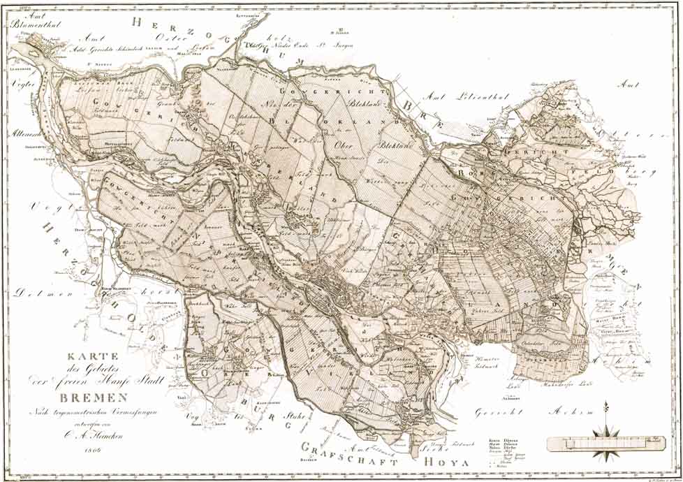
Deutsch: Originaltitel: „KARTE / des Gebietes / Der freien Hanſe Stadt / BREMEN / Nach trigonometrischen Vermessungen / entworfen von / C. A. Heineken / 1806“ – Maßstab ca. 1:42.000 – Es handelt sich quasi um die 2. Auflage der Übersichtskarte der ersten genauen Landesaufnahme des bremischen Staatsgebietes. Die erste war, ebenfalls unter der Autorschaft Heinekens, 1798 erschienen und nun durch die Gebietsgewinne auf dem Reichsdeputationshauptschluss 1803 nicht mehr aktuell. Erst am 20. November 1806 kam Bremen unter französische Besatzung. Am 18. Dezember 1810 wurde die alte Verfassung aufgehoben und 1. Januar 1811 Bremen von Frankreich annektiert. Am 25. Oktober 1813 endete die französische Besatzung, und am 6. November 1813 wurde die Freie Hansestadt Bremen in den Grenzen von 1803 und mit der bis 1810 gültigen Verfassung wiederhergestellt. English: Translation of the title: "Map of the territory of the Free Hanseatic city of Bremen", designed by C. A. Heineken according to a trigonometric survey" – scale about 1:42,000 – This map is basically a revised edition of the map published by Keineken in 1798, which had become outdated due to the enlargement of the territory of Bremen following the German mediatization in 1803. |
| Date | |
| Source | http://www.ra.se/KRA/0406fg.html |
| Author | C. A. Heineken |
| Other versions | File:Karte_des_Gebietes_der_freien_Hanse_Stadt_Bremen_1806.jpg (better resolution: 4,045 × 2,823 px) |
Licensing edit
|
This work is in the public domain in its country of origin and other countries and areas where the copyright term is the author's life plus 100 years or fewer. | |
| This file has been identified as being free of known restrictions under copyright law, including all related and neighboring rights. | |
File history
Click on a date/time to view the file as it appeared at that time.
| Date/Time | Thumbnail | Dimensions | User | Comment | |
|---|---|---|---|---|---|
| current | 06:17, 19 April 2006 | | 978 × 690 (116 KB) | Tarawneh (talk | contribs) | {{Information| |Description=Bremen Old Map |Source=http://www.ra.se/KRA/0406fg.html |Date=1806 |Author= |Permission={{PD-old}} |other_versions= }} Category:Old Maps, Bremen, Germany |
You cannot overwrite this file.
File usage on Commons
The following 2 pages use this file:
- File:Bremen Old Map 6.jpg (file redirect)
- Category:Bremen in the 1800s
File usage on other wikis
The following other wikis use this file:
- Usage on de.wikipedia.org
- Usage on hu.wikipedia.org
- Usage on ru.wikipedia.org