File:Brenner base tunnel map.png

Size of this preview: 262 × 598 pixels. Other resolutions: 105 × 240 pixels | 210 × 480 pixels | 950 × 2,169 pixels.
Original file (950 × 2,169 pixels, file size: 2.34 MB, MIME type: image/png)
Captions
Captions
Add a one-line explanation of what this file represents
Summary edit
| Description |
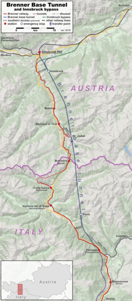
English: Map of the Brenner base tunnel (blue, under construction) and Innsbruck bypass (green), side-by side with the Brenner railway (red). |
| Date | |
| Source | Own work, using OpenStreetMap data and File:Austria_location_map.svg by Lencer and File:BSicon_uÜST.svg by Jack1254 |
| Author | Hbf878, OpenStreetMap contributors, Lencer |
| Other versions |
 |
Licensing edit
This file is licensed under the Creative Commons Attribution-Share Alike 2.0 Generic license.
- You are free:
- to share – to copy, distribute and transmit the work
- to remix – to adapt the work
- Under the following conditions:
- attribution – You must give appropriate credit, provide a link to the license, and indicate if changes were made. You may do so in any reasonable manner, but not in any way that suggests the licensor endorses you or your use.
- share alike – If you remix, transform, or build upon the material, you must distribute your contributions under the same or compatible license as the original.
| This work contains information from OpenStreetMap, which is made available under the Open Database License (ODbL).
The ODbL does not require any particular license for maps produced from ODbL data. Prior to 1 August 2020, map tiles produced by the OpenStreetMap Foundation were licensed under the CC-BY-SA-2.0 license. Maps produced by other people may be subject to other licences. |
File history
Click on a date/time to view the file as it appeared at that time.
| Date/Time | Thumbnail | Dimensions | User | Comment | |
|---|---|---|---|---|---|
| current | 08:30, 26 July 2023 | | 950 × 2,169 (2.34 MB) | Hbf878 (talk | contribs) | typo |
| 21:49, 29 April 2020 |  | 950 × 2,169 (2.34 MB) | Hbf878 (talk | contribs) | visibility | |
| 14:02, 17 November 2019 |  | 950 × 2,169 (2.34 MB) | Hbf878 (talk | contribs) | User created page with UploadWizard |
You cannot overwrite this file.
File usage on Commons
The following 17 pages use this file:
- User:Anton-kurt/Tyrol new files/2019 November 11-20
- User:Anton-kurt/Tyrol new files/2020 April 21-30
- User:Chumwa/OgreBot/Potential transport maps/2019 November 11-20
- User:Chumwa/OgreBot/Public transport information/2019 November 11-20
- User:Chumwa/OgreBot/Public transport information/2020 April 21-30
- User:Chumwa/OgreBot/Public transport information/2023 July 21-31
- User:Chumwa/OgreBot/Transport Maps/2019 November 11-20
- User:Chumwa/OgreBot/Transport Maps/2020 April 21-30
- User:Chumwa/OgreBot/Transport Maps/2023 July 21-31
- User:J budissin/Uploads/BiH/2019 November 11-20
- User:J budissin/Uploads/BiH/2020 April 21-30
- User:Luftschiffhafen/Tyrol/2023 July 21-31
- User:Mai-Sachme/South Tyrol/2019 November 11-20
- User:Mai-Sachme/South Tyrol/2020 April 21-30
- User:Mai-Sachme/South Tyrol/2023 July 21-31
- File:Karte Brennerbasistunnel.png
- Category:Brenner Basistunnel
File usage on other wikis
The following other wikis use this file:
- Usage on en.wikipedia.org
- Usage on fi.wikipedia.org
- Usage on hu.wikipedia.org
- Usage on sk.wikipedia.org
- Usage on sl.wikipedia.org
- Usage on www.wikidata.org