File:Brick-shuttered pillbox by fishing lakes north of the A47 road - geograph.org.uk - 1745983.jpg
No higher resolution available.
Brick-shuttered_pillbox_by_fishing_lakes_north_of_the_A47_road_-_geograph.org.uk_-_1745983.jpg (640 × 480 pixels, file size: 219 KB, MIME type: image/jpeg)
Captions
Captions
Add a one-line explanation of what this file represents
Summary
edit
| Description |
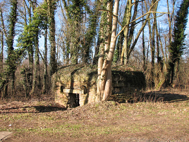
English: Brick-shuttered pillbox by fishing lakes north of the A47 road This pillbox is not listed in the Defence of Britain database. It is situated beside an unsurfaced track leading past several fishing lakes north of the A47 road. The lakes are used by members of the Swaffham Angling Club. |
| Date | |
| Source | From geograph.org.uk |
| Author | Evelyn Simak |
| Attribution (required by the license) | Evelyn Simak / Brick-shuttered pillbox by fishing lakes north of the A47 road / |
| Camera location | | View this and other nearby images on: OpenStreetMap |
|---|
_heading:292.00&language=en)
| Object location | | View this and other nearby images on: OpenStreetMap |
|---|
_heading:292.00&language=en)
Licensing
edit

|
This image was taken from the Geograph project collection. See this photograph's page on the Geograph website for the photographer's contact details. The copyright on this image is owned by Evelyn Simak and is licensed for reuse under the Creative Commons Attribution-ShareAlike 2.0 license.
|
This file is licensed under the Creative Commons Attribution-Share Alike 2.0 Generic license.
Attribution: Evelyn Simak
- You are free:
- to share – to copy, distribute and transmit the work
- to remix – to adapt the work
- Under the following conditions:
- attribution – You must give appropriate credit, provide a link to the license, and indicate if changes were made. You may do so in any reasonable manner, but not in any way that suggests the licensor endorses you or your use.
- share alike – If you remix, transform, or build upon the material, you must distribute your contributions under the same or compatible license as the original.
File history
Click on a date/time to view the file as it appeared at that time.
| Date/Time | Thumbnail | Dimensions | User | Comment | |
|---|---|---|---|---|---|
| current | 18:21, 5 March 2011 | | 640 × 480 (219 KB) | GeographBot (talk | contribs) | == {{int:filedesc}} == {{Information |description={{en|1=Brick-shuttered pillbox by fishing lakes north of the A47 road This pillbox is not listed in the Defence of Britain database. It is situated beside an unsurfaced track leading past several fishing l |
You cannot overwrite this file.
File usage on Commons
There are no pages that use this file.