File:Bristly mousetails, Myosurus apetalus var. montanus (42699631504).jpg

Original file (2,218 × 1,664 pixels, file size: 1.96 MB, MIME type: image/jpeg)
Captions
Captions
Summary edit
.jpg&action=edit§ion=1)
| Description |
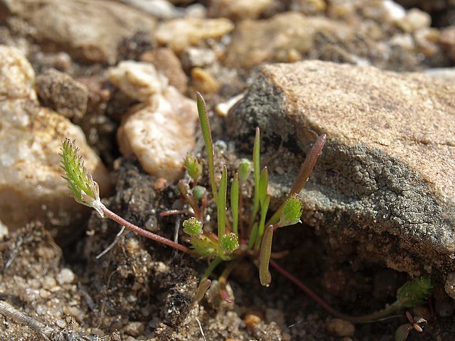
bristly mousetails, Myosurus apetalus var. montanus, Nevada, Pine Nut Mountains, Hot Springs Mountain, Carson Valley drainage, elevation 1449 m (4755 ft). When mousetails are growing in open desert, you know it has been a wet year. Usually these relatives of buttercups are found in moister habitats. In North America this species is found at middle to subalpine elevations from southwestern Canada southward through most of the western United States. As the scientific name suggests, the petals are small, inconspicuous, fall off early, and usually seem to be missing. The other variety of the species, var. apetalus, is found in similar habitats in Chile and Argentina. There are a bunch of species with similar "amphitropical" distributions in North and South America, and most of them are annuals of moist to wet habitats with small light seeds. Most likely their ancestors were transported occasionally between the two areas in the past by migrating waterfowl. |
| Date | |
| Source | bristly mousetails, Myosurus apetalus var. montanus |
| Author | Jim Morefield from Nevada, USA |
| Camera location | | View this and other nearby images on: OpenStreetMap |
|---|
.jpg¶ms=039.093700_N_-119.720231_E_globe:Earth_type:camera_source:Flickr_&language=en)
Licensing edit
.jpg&action=edit§ion=2)
- You are free:
- to share – to copy, distribute and transmit the work
- to remix – to adapt the work
- Under the following conditions:
- attribution – You must give appropriate credit, provide a link to the license, and indicate if changes were made. You may do so in any reasonable manner, but not in any way that suggests the licensor endorses you or your use.
- share alike – If you remix, transform, or build upon the material, you must distribute your contributions under the same or compatible license as the original.
| This image was originally posted to Flickr by Jim Morefield at https://flickr.com/photos/127605180@N04/42699631504 (archive). It was reviewed on 29 December 2019 by FlickreviewR 2 and was confirmed to be licensed under the terms of the cc-by-sa-2.0. |
File history
Click on a date/time to view the file as it appeared at that time.
| Date/Time | Thumbnail | Dimensions | User | Comment | |
|---|---|---|---|---|---|
| current | 03:04, 29 December 2019 | | 2,218 × 1,664 (1.96 MB) | Ser Amantio di Nicolao (talk | contribs) | Transferred from Flickr via #flickr2commons |
You cannot overwrite this file.
File usage on Commons
There are no pages that use this file.
.jpg&oldid=834048323)