File:British Empire Map (Indonesian).svg

Size of this PNG preview of this SVG file: 800 × 406 pixels. Other resolutions: 320 × 162 pixels | 640 × 324 pixels | 1,024 × 519 pixels | 1,280 × 649 pixels | 2,560 × 1,298 pixels | 939 × 476 pixels.
Original file (SVG file, nominally 939 × 476 pixels, file size: 940 KB)
Captions
Captions
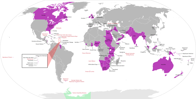
British Empire map in Indonesian
Summary
edit.svg&action=edit§ion=1)
| Description |
English: Anachronous map of British Empire in Indonesian
Bahasa Indonesia: Peta anakronis dari wilayah-wilayah yang dikolonisasi Britania |
| Date | |
| Source |
This file was derived from: British Empire Map (Chinese).svg: |
| Author |
|
.svg)
Licensing
edit.svg&action=edit§ion=2)
| I, the copyright holder of this work, release this work into the public domain. This applies worldwide. In some countries this may not be legally possible; if so: I grant anyone the right to use this work for any purpose, without any conditions, unless such conditions are required by law. |
File history
Click on a date/time to view the file as it appeared at that time.
| Date/Time | Thumbnail | Dimensions | User | Comment | |
|---|---|---|---|---|---|
| current | 12:27, 16 October 2020 | | 939 × 476 (940 KB) | AnsyahF (talk | contribs) | Uploaded a work by Original by Nv7801, translated by Astronom5109 from {{Derived from|British_Empire_Map_(Chinese).svg|display=50}} with UploadWizard |
You cannot overwrite this file.
File usage on Commons
There are no pages that use this file.
File usage on other wikis
The following other wikis use this file:
- Usage on id.wikipedia.org
- Usage on ko.wikipedia.org
- Usage on min.wikipedia.org
.svg&oldid=834289234)