File:British Isles Venn Diagram-de.svg

Size of this PNG preview of this SVG file: 581 × 600 pixels. Other resolutions: 233 × 240 pixels | 465 × 480 pixels | 744 × 768 pixels | 992 × 1,024 pixels | 1,984 × 2,048 pixels | 591 × 610 pixels.
Original file (SVG file, nominally 591 × 610 pixels, file size: 1 KB)
Captions
Captions
Add a one-line explanation of what this file represents
Summary
edit
| Description | |
| Date | |
| Source | Own work (Original text: Own work + File:British_Isles_Venn_Diagram.png) |
| Author | Emdee |
| Other versions | File:British_Isles_Venn_Diagram.png |
| SVG development | This diagram was created with a text editor. This diagram uses embedded text that can be easily translated using a text editor. |
Licensing
edit
| I, the copyright holder of this work, release this work into the public domain. This applies worldwide. In some countries this may not be legally possible; if so: I grant anyone the right to use this work for any purpose, without any conditions, unless such conditions are required by law. |
File history
Click on a date/time to view the file as it appeared at that time.
| Date/Time | Thumbnail | Dimensions | User | Comment | |
|---|---|---|---|---|---|
| current | 20:00, 9 April 2021 | | 591 × 610 (1 KB) | Mrmw (talk | contribs) | |
| 20:14, 24 April 2020 |  | 591 × 610 (1 KB) | Mrmw (talk | contribs) | edit // Editing SVG source code using c:User:Rillke/SVGedit.js | |
| 20:04, 24 April 2020 |  | 591 × 610 (1 KB) | Mrmw (talk | contribs) | white background // Editing SVG source code using c:User:Rillke/SVGedit.js | |
| 19:50, 24 April 2020 |  | 591 × 610 (1 KB) | Mrmw (talk | contribs) | text as text | |
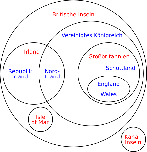
| 18:48, 12 July 2009 |  | 256 × 263 (40 KB) | Emdee (talk | contribs) | {{Information |Description={{en|1=Geographical locations are shown in red, political entities are in blue.}} |Source=Own work + en:File:British_Isles_Venn_Diagram.png |Author=Emdee |Date=2009-07-12 |Permission= |other_versions=[[:en:Fi |
You cannot overwrite this file.
File usage on Commons
The following 4 pages use this file:
.png)
File usage on other wikis
The following other wikis use this file:
- Usage on de.wikipedia.org
- Großbritannien (Insel)
- Diskussion:Großbritannien (Insel)
- Diskussion:Britische Inseln
- Portal Diskussion:Inseln/Archiv/2008/3
- Wikipedia:Fragen zur Wikipedia/Archiv/2009/Woche 28
- Wikipedia:Löschkandidaten/10. Dezember 2009
- Wikipedia:WikiProjekt Kategorien/Diskussionen/2009/Dezember/10
- Benutzer:Ulflulfl/Karten
- Wikipedia:Fragen zur Wikipedia/Archiv/2011/Woche 32
- Wikipedia:Auskunft/Archiv/2011/Woche 33
- Wikipedia Diskussion:Kategorien/Archiv/2011-IV
- Wikipedia:Dresden/Archiv/2011
- Wikipedia:WikiProjekt Kategorien/Diskussionen/2023/Januar/30
- Wikipedia:Löschkandidaten/30. Januar 2023
- Usage on frr.wikipedia.org