File:British diagram.PNG

Size of this preview: 800 × 555 pixels. Other resolutions: 320 × 222 pixels | 640 × 444 pixels | 882 × 612 pixels.
Original file (882 × 612 pixels, file size: 34 KB, MIME type: image/png)
Captions
Captions
Add a one-line explanation of what this file represents
Summary
edit
| Description |
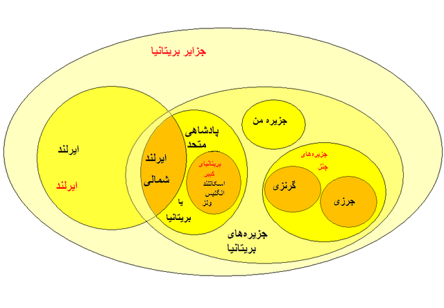
مکانهایی صرفا جغرافیایی.
نهاد سیاسی (که ممکن است واژه ای جغرافیایی نیز باشد). |
| Source | اثر_شخصی_توسط_بارگذار. اما اطلاعات برگرفته از اینجا و اینجا |
| Author | زرشک |
اجازهنامه:
edit
| I, the copyright holder of this work, release this work into the public domain. This applies worldwide. In some countries this may not be legally possible; if so: I grant anyone the right to use this work for any purpose, without any conditions, unless such conditions are required by law. |
File history
Click on a date/time to view the file as it appeared at that time.
| Date/Time | Thumbnail | Dimensions | User | Comment | |
|---|---|---|---|---|---|
| current | 13:45, 25 May 2009 | | 882 × 612 (34 KB) | زرشک (talk | contribs) | {{اطلاعات |توضیحات = رفع شبهه در مورد نامگذاریهای مربوط به انگلیس، ایرلند، و بریتانیا بطریق نمودار اویلر. {{legend|#ff2828|مکانهایی صرفا جغرافی |
You cannot overwrite this file.
File usage on Commons
There are no pages that use this file.
File usage on other wikis
The following other wikis use this file:
- Usage on fa.wikipedia.org