File:Bruce Campbell Field-MS-12Feb1996-USGS.jpg
No higher resolution available.
Bruce_Campbell_Field-MS-12Feb1996-USGS.jpg (338 × 490 pixels, file size: 54 KB, MIME type: image/jpeg)
Captions
Captions
Add a one-line explanation of what this file represents
Summary
edit
| Description |
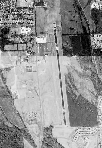
English: USGS digital orthophoto of Bruce Campbell Field, an airport in Madison, Mississippi, United States |
| Date | |
| Source |
USGS The National Map, via MSR Maps (formerly TerraServer-USA) |
| Author | United States Geological Survey (USGS) |
| Permission (Reusing this file) |
Public domain |
Licensing
edit
This image is in the public domain in the United States because it only contains materials that originally came from the United States Geological Survey, an agency of the United States Department of the Interior. For more information, see the official USGS copyright policy.
|
File history
Click on a date/time to view the file as it appeared at that time.
| Date/Time | Thumbnail | Dimensions | User | Comment | |
|---|---|---|---|---|---|
| current | 05:19, 7 March 2010 | | 338 × 490 (54 KB) | Bwmoll3 (talk | contribs) | {{Information |Description={{en|1=Bruce Campbell Field Airport, Madison, Mississippi, USA}} |Source=US Geological Survey http://msrmaps.com/map.aspx?t=1&s=12&lon=-90.103056&lat=32.438611&w=600&h=800 |Author=US Geological Survey |Date=12 Feb 1996 |Permissi |
You cannot overwrite this file.
File usage on Commons
There are no pages that use this file.
File usage on other wikis
The following other wikis use this file:
- Usage on fa.wikipedia.org
- Usage on tg.wikipedia.org