File:Brundall railway station - signal box - geograph.org.uk - 1531804.jpg
No higher resolution available.
Brundall_railway_station_-_signal_box_-_geograph.org.uk_-_1531804.jpg (640 × 571 pixels, file size: 141 KB, MIME type: image/jpeg)
Captions
Captions
Add a one-line explanation of what this file represents
Summary edit
| Description |
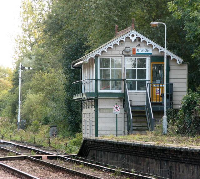
English: Brundall railway station - signal box In this close-up view of the signal box the signal wires and the point rodding can clearly be seen.
Brundall railway station > https://www.geograph.org.uk/photo/1531781 is located on the Wherry Lines and served by National Express East Anglia, linking Norwich with Great Yarmouth and Lowestoft. The presently unstaffed station is a junction > https://www.geograph.org.uk/photo/1531797 on the Brundall and Yarmouth, and the Norwich and Yarmouth lines - the line to Great Yarmouth (via Acle) diverges from the line to Lowestoft and Great Yarmouth (via Reedham). The station building now houses a shop > https://www.geograph.org.uk/photo/1531783. There is a manned signalbox east of the westbound platform and a brick hut > https://www.geograph.org.uk/photo/1531792 beside the crossing gates on Station Road for the crossing keeper who manually opens/closes the crossing gates > https://www.geograph.org.uk/photo/1531829. A footbridge > https://www.geograph.org.uk/photo/1531824 over the line gives access to the westbound platform. |
| Date | |
| Source | From geograph.org.uk |
| Author | Evelyn Simak |
| Attribution (required by the license) | Evelyn Simak / Brundall railway station - signal box / |
| Camera location | | View this and other nearby images on: OpenStreetMap |
|---|
_heading:135.00&language=en)
| Object location | | View this and other nearby images on: OpenStreetMap |
|---|
_heading:135.00&language=en)
Licensing edit

|
This image was taken from the Geograph project collection. See this photograph's page on the Geograph website for the photographer's contact details. The copyright on this image is owned by Evelyn Simak and is licensed for reuse under the Creative Commons Attribution-ShareAlike 2.0 license.
|
This file is licensed under the Creative Commons Attribution-Share Alike 2.0 Generic license.
Attribution: Evelyn Simak
- You are free:
- to share – to copy, distribute and transmit the work
- to remix – to adapt the work
- Under the following conditions:
- attribution – You must give appropriate credit, provide a link to the license, and indicate if changes were made. You may do so in any reasonable manner, but not in any way that suggests the licensor endorses you or your use.
- share alike – If you remix, transform, or build upon the material, you must distribute your contributions under the same or compatible license as the original.
File history
Click on a date/time to view the file as it appeared at that time.
| Date/Time | Thumbnail | Dimensions | User | Comment | |
|---|---|---|---|---|---|
| current | 05:59, 3 March 2011 | | 640 × 571 (141 KB) | GeographBot (talk | contribs) | == {{int:filedesc}} == {{Information |description={{en|1=Brundall railway station - signal box In this close-up view of the signal box the signal wires and the point rodding can clearly be seen. Brundall railway station > http://www.geograph.org.uk/pho |
You cannot overwrite this file.
File usage on Commons
There are no pages that use this file.
File usage on other wikis
The following other wikis use this file:
- Usage on en.wikipedia.org
- Usage on www.wikidata.org