File:Brunei-Temburong.png
No higher resolution available.
Brunei-Temburong.png (100 × 80 pixels, file size: 2 KB, MIME type: image/png)
Captions
Captions
Add a one-line explanation of what this file represents
Summary
edit
| Description |
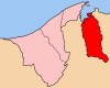
English: Map of the Temburong District of Brunei — in the northwest of the island of Borneo.
Deutsch: Karte Bruneis mit den Temburong-Distrikt (koloriert)
Suomi: Temburongin piirikunta
Français : Carte de Brunei mettant le district de Temburong en évidence.
Русский: Map of Brunei showing Temburong district. |
| Date | |
| Source | Self-made, traced from public domain UN or CIA maps. |
| Author | User:Golbez |
| Permission (Reusing this file) |
Provide attribution, please. See below. |
| Other versions | See Image:Brunei districts numbered.png for the numbered map of the districts. |
I, the copyright holder of this work, hereby publish it under the following licenses:
This file is licensed under the Creative Commons Attribution-Share Alike 2.5 Generic, 2.0 Generic and 1.0 Generic license.
- You are free:
- to share – to copy, distribute and transmit the work
- to remix – to adapt the work
- Under the following conditions:
- attribution – You must give appropriate credit, provide a link to the license, and indicate if changes were made. You may do so in any reasonable manner, but not in any way that suggests the licensor endorses you or your use.
- share alike – If you remix, transform, or build upon the material, you must distribute your contributions under the same or compatible license as the original.

|
Permission is granted to copy, distribute and/or modify this document under the terms of the GNU Free Documentation License, Version 1.2 or any later version published by the Free Software Foundation; with no Invariant Sections, no Front-Cover Texts, and no Back-Cover Texts. A copy of the license is included in the section entitled GNU Free Documentation License. |
| This file is licensed under the Creative Commons Attribution-Share Alike 3.0 Unported license. | ||
| ||
| This licensing tag was added to this file as part of the GFDL licensing update. |
You may select the license of your choice.

|
This locator map image could be re-created using vector graphics as an SVG file. This has several advantages; see Commons:Media for cleanup for more information. If an SVG form of this image is available, please upload it and afterwards replace this template with
{{vector version available|new image name}}.
It is recommended to name the SVG file “Brunei-Temburong.svg”—then the template Vector version available (or Vva) does not need the new image name parameter. |
en:Category:Temburong District
File history
Click on a date/time to view the file as it appeared at that time.
| Date/Time | Thumbnail | Dimensions | User | Comment | |
|---|---|---|---|---|---|
| current | 06:10, 31 December 2004 | | 100 × 80 (2 KB) | Golbez (talk | contribs) | Sharper version |
| 07:20, 18 December 2004 |  | 100 × 81 (3 KB) | Golbez (talk | contribs) | Map of Brunei showing Temburong district. Made by User:Golbez. {{cc-by-sa-2.0}} |
You cannot overwrite this file.
File usage on Commons
There are no pages that use this file.
File usage on other wikis
The following other wikis use this file:
- Usage on bs.wikipedia.org
- Usage on de.wikipedia.org
- Usage on el.wikipedia.org
- Usage on es.wikipedia.org
- Usage on fa.wikipedia.org
- Usage on gl.wikipedia.org
- Usage on ja.wikipedia.org
- Usage on ps.wikipedia.org
- Usage on sh.wikipedia.org
- Usage on sr.wikipedia.org
- Usage on ur.wikipedia.org