File:Brunei map-fr.svg

Size of this PNG preview of this SVG file: 527 × 599 pixels. Other resolutions: 211 × 240 pixels | 422 × 480 pixels | 676 × 768 pixels | 901 × 1,024 pixels | 1,802 × 2,048 pixels | 938 × 1,066 pixels.
Original file (SVG file, nominally 938 × 1,066 pixels, file size: 181 KB)
Captions
Captions
Add a one-line explanation of what this file represents
Summary
edit
| Description |
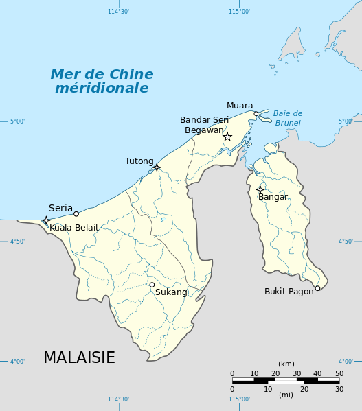
English: Location map of Brunei. Equirectangular projection centered at 4°39′00″N 114°45′00″E / 4.65000°N 114.75000°E.
Deutsch: Positionskarte Karte von Brunei. Quadratische Plattkarte, Zentrum: 4°39′00″N 114°45′00″E / 4.65000°N 114.75000°E.
Français : Carte géolocalisée du Brunei. Projection équirectangulaire centrée en 4°39′00″N 114°45′00″E / 4.65000°N 114.75000°E.
Geographic limits of the map:
|
| Date | |
| Source |
|
| Author | Tachymètre |
| Other versions | English version |
| SVG development |
Licensing
edit
| This work has been released into the public domain by its author, Tachymètre. This applies worldwide. In some countries this may not be legally possible; if so: |
File history
Click on a date/time to view the file as it appeared at that time.
| Date/Time | Thumbnail | Dimensions | User | Comment | |
|---|---|---|---|---|---|
| current | 13:43, 26 February 2011 | | 938 × 1,066 (181 KB) | Tachymètre (talk | contribs) | {{Created with Inkscape}} == {{int:filedesc}} == {{Information |Description= {{en|Location map of Brunei. Equirectangular projection centered at {{coor d|4.65000|N|114.75000|E|scale:1020000}}.}} {{de|Posit |
You cannot overwrite this file.
File usage on Commons
There are no pages that use this file.
File usage on other wikis
The following other wikis use this file:
- Usage on fr.wikipedia.org