File:Brussels sands.PNG
No higher resolution available.
Brussels_sands.PNG (470 × 599 pixels, file size: 241 KB, MIME type: image/png)
Captions
Captions
Add a one-line explanation of what this file represents
Summary
edit
| Description |
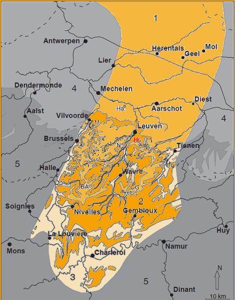
English: Occurrence of the Brussels Sands in Central Belgium.
1 = subcrop; 2 = outcrop; 3 = eroded outcrop; 4 = no Brussels Sands, with younger cover; 5 = no Brussels Sands, older outcrops. Brussels Sands basin = 1 + 2 + 3. Localities mentioned in picture : Ar: Archennes; B: Bierbeek; BA: Braine-l’Alleud; CG: Chaumont-Gistoux; Ha: Haacht; Ho: Hoegaarden; Hr: Haasrode; M: Machelen; MSG : Mont-Saint-Guibert; N: Neerijse.Русский: Расположение Брюссельских песков в Центральной Бельгии.
1 = в толще; 2 = выход на поверхность; 3 = эродированный выход но поверхность; 4 = Брюссельские пески, не покрытые более поздними отложениями; 5 = нет Брюссельских песков, более ранние отложения. Места, отмеченные на карте: Ar: Археннес; B: Бирбек; BA: Браин-л’Аллёд; CG: Шамон-Гисту; Ha: Хахт; Ho: Хугарден; Hr: Хасроде; M: Махелен; MSG : Мон-Сан-Гюбер; N: Нерейсе |
| Date | |
| Source | GEOLOGICA BELGICA (2011) 14/1-2: 55-74 |
| Author | Rik HOUTHUYS |
Licensing
edit
This file is licensed under the Creative Commons Attribution 3.0 Unported license.
- You are free:
- to share – to copy, distribute and transmit the work
- to remix – to adapt the work
- Under the following conditions:
- attribution – You must give appropriate credit, provide a link to the license, and indicate if changes were made. You may do so in any reasonable manner, but not in any way that suggests the licensor endorses you or your use.
File history
Click on a date/time to view the file as it appeared at that time.
| Date/Time | Thumbnail | Dimensions | User | Comment | |
|---|---|---|---|---|---|
| current | 00:17, 12 October 2012 | | 470 × 599 (241 KB) | Ciaurlec (talk | contribs) | Coloured |
| 12:43, 26 October 2010 |  | 605 × 771 (129 KB) | Lenaraz2 (talk | contribs) | {{Information |Description={{en|1=Occurrence of the Brussels Sands in Central Belgium. 1 = subcrop; 2 = outcrop; 3 = eroded outcrop; 4 = no Brussels Sands, with younger cover; 5 = no Brussels Sands, older outcrops. Brussels Sands basin = 1 + 2 + 3. Loca |
You cannot overwrite this file.
File usage on Commons
There are no pages that use this file.
File usage on other wikis
The following other wikis use this file:
- Usage on nl.wikipedia.org